Filter: Categories of Wisconsin Historical Images
Filter: County of Douglas
Filter: Subject of botany
Filter: Subject of human settlements
Filter: Subject of transportation
Filter: Categories of Wisconsin Historical Images
Filter: County of Douglas
Filter: Subject of botany
Filter: Subject of human settlements
Filter: Subject of transportation

| Date: | 1883 |
|---|---|
| Description: | Bird's-eye map of Superior, county seat of Douglas County, on the shores of Lake Superior, with insets of points of interest. |

| Date: | 1930 |
|---|---|
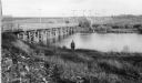
| Description: | View of bridge and Brule River monument. Placed where the Brule River is crossed by the Memorial Highway from Superior to Brule and Ashland (Highway 2). |
| Date: | 1953 |
|---|---|
| Description: | Nemadji River at the foot of 2nd Avenue and Robertson Avenue. A man is standing near the grassy shoreline in the center. |
| Date: | 1910 |
|---|---|
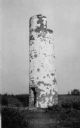
| Description: | View of the remnants of the Minnesota Point Lighthouse. Faint caption at bottom reads: "Lighthouse". |
| Date: | 1930 |
|---|---|
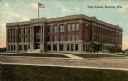
| Description: | Exterior view across street towards a high school. Caption reads: "High School, Superior, Wis." |
| Date: | 1915 |
|---|---|
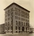
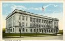
| Description: | Exterior view of the Douglas County Courthouse. Caption reads: "Court House, Superior, Wis." |
| Date: | 1930 |
|---|---|
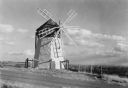
| Description: | View of the Davidson Feed Mill near the Amnicon River. |
| Date: | 1919 |
|---|---|
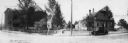
| Description: | Panoramic view of county buildings located at West 5th and Newton Avenues. |
| Date: | 1940 |
|---|---|
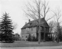
| Description: | Exterior view of the Butler home. |

| Date: | 1960 |
|---|---|
| Description: | Aerial view with docks in the foreground. Caption reads: "Superior, Wisconsin." |

| Date: | 1985 |
|---|---|
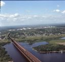
| Description: | Aerial view of the Duluth-Superior Bridge, officially named in honor of Richard I. Bong, World War II's Ace of Aces, who hailed from nearby Poplar, Wiscons... |
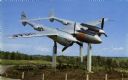
| Date: | 1965 |
|---|---|
| Description: | View of the Bong Memorial, dedicated to the memory of World War II air ace Major Richard I. Bong. This P-38 is the type of plane he piloted when he shot do... |
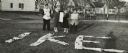
| Date: | 11 1952 |
|---|---|
| Description: | John Lavine (left), Nancy Jane Nelson, Virginia Rafshol, and Gary Berger indicate their support for the presidential candidacy of Dwight D. Eisenhower. As ... |
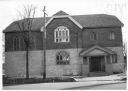
| Date: | 02 1977 |
|---|---|
| Description: | Exterior view from street of the Hebrew Brotherhood Synagogue. |
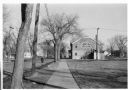
| Date: | 02 1977 |
|---|---|
| Description: | View down sidewalk towards the exterior of the Hebrew Brotherhood Synagogue. |
| Date: | 08 1971 |
|---|---|
| Description: | Aerial view of an ore dock next to Hog Island. The town is in the distance. In the far background are the white storage buildings of the oil refinery. |

| Date: | 07 04 1889 |
|---|---|
| Description: | Elevated view looking south along unpaved Tower Avenue of storefronts, American flags are flying from a number of the commercial buildings. |
| Date: | 1950 |
|---|---|
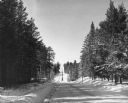
| Description: | A snow-covered road disappears over a hill on a county highway between the Brule River and Lake Nebagamon. Pine trees line both sides of the road. |
| Date: | 1907 |
|---|---|
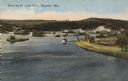
| Description: | Text on front reads: "Scene on St. Louis River, Superior, Wis." Elevated view of the St. Louis River emptying into an fresh water estuary on its way to Lak... |
If you didn't find the material you searched for, our Library Reference Staff can help.
Call our reference desk at 608-264-6535 or email us at: