Filter: Categories of Wisconsin Historical Images
Filter: County of Door
Filter: Subject of streets
Filter: Categories of Wisconsin Historical Images
Filter: County of Door
Filter: Subject of streets
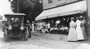
| Date: | 06 27 1912 |
|---|---|
| Description: | Suffragist Mrs. Katherine McCullough speaking to a gathering in front of the store and post office run by Mrs. W. Bunda in Sister Bay. |
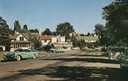
| Date: | 1950 |
|---|---|
| Description: | View of cars parked alongside businesses on Third Street. Bassett's Drugstore is on the left side of the street. |
| Date: | 1912 |
|---|---|
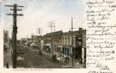
| Description: | View of Cedar Street looking northwards. Bassett's Drugstore is on the right, and the General Store is directly across the street. Caption reads: "Cedar St... |

| Date: | 1893 |
|---|---|
| Description: | Bird's-eye map of Sturgeon Bay, looking Northeast. Area bordered by Church Street in top left corner, leather & Smith Bridge in bottom left corner, Lawrenc... |
| Date: | 1910 |
|---|---|
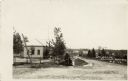
| Description: | Street scene in Ellison Bay. On the far left is a building with a bell tower on the roof. Caption reads: "St. Scene, Ellison Bay, Wis." |
| Date: | 1909 |
|---|---|
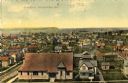
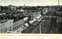
| Description: | Elevated view of the First Ward. Caption reads: "First Ward, Sturgeon Bay, Wis." |
| Date: | 1911 |
|---|---|
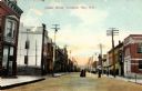
| Description: | View down Cedar Street. Caption reads: "Cedar Street, Sturgeon Bay, Wis." |
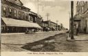
| Date: | 1912 |
|---|---|
| Description: | Elevated view of Cedar Street. Caption reads: "Cedar Street, Sturgeon Bay, Wis." |

| Date: | 1905 |
|---|---|
| Description: | Caption reads: "Cedar Street, North. Sturgeon Bay, Wis." |
| Date: | 1907 |
|---|---|
| Description: | Elevated view of Cedar Street. Caption reads: "Cedar Street, Looking South, Sturgeon Bay, Wis." |

| Date: | 1912 |
|---|---|
| Description: | View from left sidewalk towards the west side of Cedar Street. Caption reads: "West Side of Cedar Street Sturgeon Bay, Wis." |

| Date: | 1912 |
|---|---|
| Description: | Exterior view from street towards a Catholic church and parsonage. Caption reads: "Catholic Church and Parsonage, Sturgeon Bay, Wis." |
| Date: | |
|---|---|
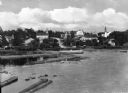
| Description: | View of Eagle Harbor and the area surrounding Church Street. On the right, Ephraim Moravian Church, completed in 1859, can be seen among residential buildi... |
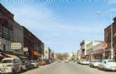
| Date: | 1918 |
|---|---|
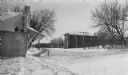
| Description: | Winter scene looking east on Main Street (Highway 42), with wooden commercial buildings on both sides of the street. The building on the left, 4168 Main St... |
| Date: | 02 1924 |
|---|---|
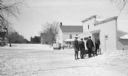
| Description: | Three men stand behind a horse-drawn enclosed sleigh in front of the Lundberg Store on Fish Creek's Main Street. There is a second sleigh and horse in the ... |

| Date: | 1860 |
|---|---|
| Description: | This map of Dodge County, Wisconsin, shows the township and range grid, towns, sections, cities and villages, railroads, roads, property owners and acreage... |

| Date: | 1987 |
|---|---|
| Description: | This 1987 map of Door County, Wisconsin, shows streets and roads, cities and villages, state parks, lakes and streams, and depths in Lake Michigan. A stree... |

| Date: | |
|---|---|
| Description: | View from road of the Panter Hotel and Sandwich Shoppe, which has a wrap-around porch with bushes planted in front. There are plants in a stone planter in ... |

| Date: | 1972 |
|---|---|
| Description: | Aerial view of commercial buildings and dwellings along the shore of Lake Michigan. Caption reads: "Baileys Harbor, Wisc." |
If you didn't find the material you searched for, our Library Reference Staff can help.
Call our reference desk at 608-264-6535 or email us at: