 Filter: Categories of Wisconsin Historical Images
Filter: County of Dane
Filter: Subject of streets
Filter: Subject of presbyterian churches
Filter: Categories of Wisconsin Historical Images
Filter: County of Dane
Filter: Subject of streets
Filter: Subject of presbyterian churches
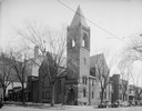
| Date: | 05 10 1929 |
|---|---|
| Description: | View from across street of the Christ Presbyterian Church, located at 124 Wisconsin Avenue at Dayton Street. |
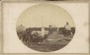
| Date: | |
|---|---|
| Description: | A view looking south down Wisconsin Avenue toward the Capitol Square where portions of the second and third Wisconsin State Capitols are visible. This pers... |

| Date: | 1933 |
|---|---|
| Description: | View of the Presbyterian student chapel at the intersection of State and Murray Streets. |

| Date: | 1933 |
|---|---|
| Description: | View of the student chapel located at the intersection of State and Murray Streets. |

| Date: | 03 25 1951 |
|---|---|
| Description: | Elevated view of a crowd gathered at the groundbreaking ceremony for Westminster Presbyterian Church at 4100 Nakoma Road. The homes across the street inclu... |
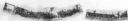
| Date: | 06 1967 |
|---|---|
| Description: | Composite panoramic view of the south side of the 700 block of State Street. Lake Street parking ramp and University of Wisconsin Extension building are vi... |

| Date: | 1969 |
|---|---|
| Description: | This map is pen and ink on paper and shows the location of churches, local streets, railroads, parks, Middleton, Shorewood Hills, Monona, Maple Bluff, McFa... |
If you didn't find the material you searched for, our Library Reference Staff can help.
Call our reference desk at 608-264-6535 or email us at: