 Filter: Categories of Wisconsin Historical Images
Filter: County of Dane
Filter: Subject of service industries
Filter: Subject of land use, rural
Filter: Categories of Wisconsin Historical Images
Filter: County of Dane
Filter: Subject of service industries
Filter: Subject of land use, rural

| Date: | 1910 |
|---|---|
| Description: | Map of Dane County rural delivery in Madison and the town of Westport. |
| Date: | 06 30 1931 |
|---|---|
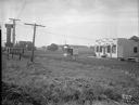
| Description: | Ray's Barbecue and Standard Oil Gas Station, on the Oregon Road (just beyond the French Village which was located at 2323 S. Park Street). |
| Date: | |
|---|---|
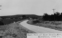
| Description: | View of rural Blue Mounds, with a two-lane, paved road. The caption at the bottom reads: "East View of Blue Mounds, Wis. Elevation, 1760 ft.". |
| Date: | 10 11 1944 |
|---|---|
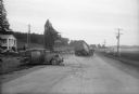
| Description: | Scene of wrecked car and semi-trailer truck in front of Alma's Inn, 5068 Highway 12-13. Injured in the accident were five men en route to work at the Badge... |
| Date: | 1964 |
|---|---|
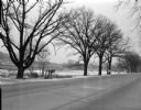
| Description: | A view to the horizon looking down Mineral Point Road, with a country house on the right under trees, during early evening hours. |
| Date: | 06 1946 |
|---|---|
| Description: | View of the 3500 block of University Avenue, site of the Coca-Cola Bottling plant. There are trees along the road and names on mailboxes of "Middleton" and... |

| Date: | 09 03 1918 |
|---|---|
| Description: | A Curtiss JN-4 "Jenny" airplane / biplane in flight over the Weber Farm south of Lake Monona. Titled in the album "The First Aeroplane in Madison". "The f... |

| Date: | 09 03 1918 |
|---|---|
| Description: | Three Curtiss JN-4 "Jenny" airplanes / biplanes parked in a field with onlookers. An automobile is parked nearby. Airplanes have a black cat symbol in a c... |

| Date: | 07 24 1960 |
|---|---|
| Description: | Laundry hangs on a clothesline and blows in the wind. There are fields behind, and low hills in the distance. |

| Date: | 07 31 1960 |
|---|---|
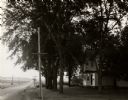
| Description: | View of a tree and mailbox, with a farmhouse behind below road level along a rural highway. There is a hill in the background with trees. |
| Date: | 07 29 1963 |
|---|---|
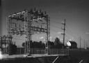
| Description: | View of a rural electric substation, with a nearby farm in the background. |
| Date: | 07 30 1960 |
|---|---|
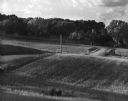
| Description: | View towards a field of corn and a farm and the power lines which run along a road. A tall industrial tower rises in the background. |
| Date: | 07 1967 |
|---|---|
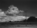
| Description: | A country road and electrical lines run through a field of oats. On the left is a road, and a farmhouse is in the background on a hill. |

| Date: | 1928 |
|---|---|
| Description: | Exterior view of gas station/restaurant outside the Triangle Tourist Park. The establishment offers Red Crown brand gasoline, Coney Island Red Hots, hot co... |
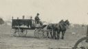
| Date: | |
|---|---|
| Description: | Black Earth hearse drawn by horses. Chris Schanel, the Black Earth undertaker, is driving. In the background on the right a small pig is running near a fen... |
| Date: | 06 24 2007 |
|---|---|
| Description: | One-page autographed menu for a six-course food and wine benefit dinner at L'Etoile Restaurant for Wisconsin Homegrown Lunch, a program promoting the use o... |

| Date: | 10 2013 |
|---|---|
| Description: | Two roads converge forming a crossroads. There are three utility poles standing in an open field of tall grass along Enchanted Valley Road which stretches ... |
If you didn't find the material you searched for, our Library Reference Staff can help.
Call our reference desk at 608-264-6535 or email us at: