 Filter: Categories of Wisconsin Historical Images
Filter: County of Dane
Filter: Subject of postal service
Filter: Subject of lakes
Filter: Categories of Wisconsin Historical Images
Filter: County of Dane
Filter: Subject of postal service
Filter: Subject of lakes

| Date: | 1910 |
|---|---|
| Description: | Map of Dane County rural delivery in Madison and the town of Westport. |

| Date: | 1876 |
|---|---|
| Description: | "View of the Capitol, with all the Flags" one of four "Different Views of Parades in the Streets" identified in Dahl's 1877 "Catalogue of Stereoscopic View... |

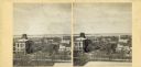
| Date: | 1870 |
|---|---|
| Description: | Stereograph looking south from the post office at the corner of Mifflin Street and Wisconsin Avenue across one corner of the Capitol Square toward Grace Ep... |

| Date: | 1876 |
|---|---|
| Description: | Elevated view from the Wisconsin State Capitol looking north to Lake Mendota along Wisconsin Avenue. City Hall is on the left, built in 1858, and the Feder... |

| Date: | 05 09 1949 |
|---|---|
| Description: | Elevated view from Park Hotel Roof of the remodeling of the Blied Building, 29 West Main Street. Other West Main Street businesses visible are Madison Bank... |

| Date: | 1915 |
|---|---|
| Description: | Wisconsin Avenue looking toward the northwest from the top of the Capitol. The elevated perspective provides an unusual view of the old City Hall (left) an... |

| Date: | 1868 |
|---|---|
| Description: | Elevated view up Wisconsin Avenue showing City Hall on the corner at Mifflin Street on the left, with the Post Office to the right. Further down is the Pre... |
| Date: | |
|---|---|
| Description: | Elevated view up Wisconsin Avenue showing City Hall with the Post Office to the right. Also visible is the Presbyterian Church. |

| Date: | 1870 |
|---|---|
| Description: | Stereograph looking south from the post office at the corner of Mifflin Street and Wisconsin Avenue across one corner of the Capitol Square toward Grace Ep... |

| Date: | 1892 |
|---|---|
| Description: | This map oriented with north to the upper left shows railroads, creeks, post offices, smaller lakes, Lake Mendota, Lake Monona, Lake Wingra, Lake Waubesa, ... |

| Date: | 1854 |
|---|---|
| Description: | This mid-19th century map of Dane County, Wisconsin, shows the township and range grid, towns, sections, cities, villages and post offices, lakes and strea... |

| Date: | 1854 |
|---|---|
| Description: | Shows street grid, sections in adjacent townships, routes of railroads and projected railroads, post offices, and creeks. Table of references identifies ma... |

| Date: | 1980 |
|---|---|
| Description: | Aerial view of Capitol Square and the surrounding central isthmus. Lake Monona is on the right. |
If you didn't find the material you searched for, our Library Reference Staff can help.
Call our reference desk at 608-264-6535 or email us at: