Filter: Categories of Wisconsin Historical Images
Filter: County of Dane
Filter: Subject of land use, rural
Filter: Subject of cities and towns
Filter: Categories of Wisconsin Historical Images
Filter: County of Dane
Filter: Subject of land use, rural
Filter: Subject of cities and towns

| Date: | 1873 |
|---|---|
| Description: | Main Street, with its dirt, ruts, cows (and presumably manure), but wide enough for easy hitching of wagons and teams. |

| Date: | 1893 |
|---|---|
| Description: | Back of painting reads: "Madison in June 1837 after photo taken by E.E. Bailey" and "Peck's cabin by Dengel." The Eben Peck cabin was the first house built... |

| Date: | |
|---|---|
| Description: | The Eben Peck cabin was the first house built in Madison. |

| Date: | 1910 |
|---|---|
| Description: | Map of Dane County rural delivery in Madison and the town of Westport. |

| Date: | 1942 |
|---|---|
| Description: | Aerial view of Oscar Mayer & Company, 910 Mayer Avenue at Packers Avenue. Shows stock yards, railroad cars and automobile parking lot. Also shows C.E. & P.... |
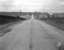
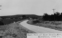
| Date: | 11 08 1928 |
|---|---|
| Description: | Stretch of paved rural highway featuring a proprietary centerline joint, looking towards Mount Horeb from the east. |
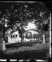
| Date: | 1872 |
|---|---|
| Description: | Ole Bull Residence, 130 East Gilman Street. The family is playing croquet on the lawn. Later, the house was known as the Thorp House. It became the state's... |

| Date: | 1873 |
|---|---|
| Description: | View, from a distance, of Middleton. The view includes A.L. Dahl's horse-drawn wagon. |
| Date: | |
|---|---|
| Description: | View of farmland near Blue Mounds, with possibly property markers horizontal, across the center, and some distant farm houses and a barn. Caption reads: "B... |
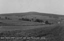
| Date: | |
|---|---|
| Description: | View of rural Blue Mounds, with a two-lane, paved road. The caption at the bottom reads: "East View of Blue Mounds, Wis. Elevation, 1760 ft.". |
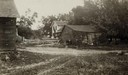
| Date: | 06 1925 |
|---|---|
| Description: | View of three farm buildings - the one in the center is collapsing. |
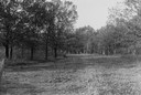
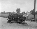
| Date: | 1930 |
|---|---|
| Description: | View of a wide path through trees in the spring or summer. |

| Date: | 1930 |
|---|---|
| Description: | Remains of the racetrack on the top of Blue Mound. |
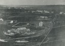
| Date: | 1860 |
|---|---|
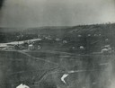
| Description: | Elevated view of multiple buildings in Cross Plains from Lutheran Church Hill. Many roads and fences cross the fields. Wooded hills are in the background. ... |
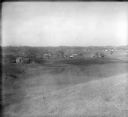
| Date: | 1928 |
|---|---|
| Description: | View from hill of uptown Cross Plains with the Catholic Church (St. Francis Xavier) and farmhouses. |

| Date: | 1955 |
|---|---|
| Description: | Aerial view of Cross Plains, with countryside surrounding and hills on the horizon. |
If you didn't find the material you searched for, our Library Reference Staff can help.
Call our reference desk at 608-264-6535 or email us at: