Filter: Categories of Wisconsin Historical Images
Filter: County of Dane
Filter: Subject of farmhouses
Filter: Subject of cities and towns
Filter: Categories of Wisconsin Historical Images
Filter: County of Dane
Filter: Subject of farmhouses
Filter: Subject of cities and towns
| Date: | 06 30 1944 |
|---|---|
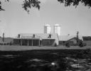
| Description: | Rennebohm Farm buildings, with house in foreground and barn and silos in background, located five miles from the Capitol, 3787 Highway 151 between Madison ... |
| Date: | 1873 |
|---|---|
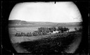
| Description: | View across field towards the Amund Rustebakke farm. Twelve haystacks dominate the left and center of the image, and two people are standing on top of the ... |
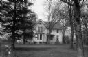
| Date: | 02 21 1927 |
|---|---|
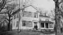
| Description: | Governor Taylor's farm home. The man standing on the porch is John Killian, owner of the farm when the photograph was taken. |
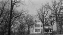
| Date: | 02 21 1927 |
|---|---|
| Description: | Governor Taylor's farm home. |
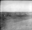
| Date: | 1928 |
|---|---|
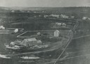
| Description: | View from hill of uptown Cross Plains with the Catholic Church (St. Francis Xavier) and farmhouses. |

| Date: | 02 03 1974 |
|---|---|
| Description: | A vine-covered stone house, 3400 Tallyho Lane, built by Joseph Statz about 1855. Later owned by builder David Stephens and then by Forest & Leonore Middle... |

| Date: | 07 26 1899 |
|---|---|
| Description: | View of the Eddie farm, later known as the Goodwin farm. |

| Date: | 1930 |
|---|---|
| Description: | Exterior view of the Renk farmhouse. |
| Date: | 04 11 1944 |
|---|---|
| Description: | William and Frederike Weber farm house on Highway 12-18, near the Yahara River south of Lake Monona. The house was also the Children's Home for Rheumatic F... |
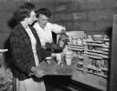
| Date: | 10 14 1948 |
|---|---|
| Description: | Jane Scalbom and Jane Gilbert Peterson opened a ceramics studio in one of the oldest buildings in Madison, the Century House, 3029 University Avenue. They ... |
| Date: | 02 03 1949 |
|---|---|
| Description: | Historic stone farmhouse at 901 University Bay Drive, recently renovated by Freda Keys Winterble. The house was named "Keystone" after her family. The far... |

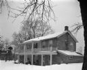
| Date: | 04 11 1949 |
|---|---|
| Description: | Harry R. Sharpe family farm home located on the University of Wisconsin poultry research farm, 5101 Mineral Point Road. |

| Date: | 1928 |
|---|---|
| Description: | View from grassy hill of uptown Cross Plains. The Catholic Church (St. Francis Xavier) is on the right, and farmhouses and other buildings are among fields... |

| Date: | 1927 |
|---|---|
| Description: | This Blue line print map shows trade area boundaries, lakes, farm homes, railways, high schools, public highways, and townships. A symbol key is included i... |
If you didn't find the material you searched for, our Library Reference Staff can help.
Call our reference desk at 608-264-6535 or email us at: