 Filter: Categories of Wisconsin Historical Images
Filter: County of Crawford
Filter: Year of 1800-1899
Filter: Subject of cities and towns
Filter: Subject of transportation
Filter: Categories of Wisconsin Historical Images
Filter: County of Crawford
Filter: Year of 1800-1899
Filter: Subject of cities and towns
Filter: Subject of transportation

| Date: | 1870 |
|---|---|
| Description: | During the War of 1812, the only battle fought in Wisconsin was in Prairie du Chien, in 1814. Made fifty-six years later, this birds eye drawing depicts th... |
| Date: | 1880 |
|---|---|
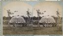
| Description: | Stereograph of the Artesian Well near the intersection of Wisconsin and Minnesota (later renamed Wacouta) Streets. The following is printed on the backside... |

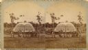
| Date: | 1895 |
|---|---|
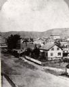
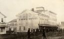
| Description: | View down road with the Bay State House on the left. Three houses and a barbershop also line the street. A lamppost is in the left foreground. The Mississ... |
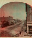
| Date: | 1870 |
|---|---|
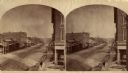
| Description: | One-half stereograph of town, elevated view looking northeast from Case's Block. |
| Date: | 1880 |
|---|---|
| Description: | Stereograph looking northeast from Case's Block. |
| Date: | 1887 |
|---|---|
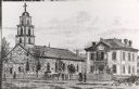
| Description: | St. Gabriel's Roman Catholic Church. Horse-drawn vehicles and pedestrians are on the street and sidewalk in front of the church. |
| Date: | 1865 |
|---|---|
| Description: | Kane's Hotel, built in about 1839 by Ezekiel Tainter, and then called the Phoenix Hotel, on Main Street. It passed through many hands but retained the orig... |

| Date: | 1840 |
|---|---|
| Description: | Fort Crawford (the second site, with buildings of 1829-?), on the east bank of the Mississippi River, about 2 miles above the mouth of the Wisconsin River. |

| Date: | 1829 |
|---|---|
| Description: | Fort Crawford, from a sketchbook attributed to Seth Eastman, 1808-1875. A graduate of West Point, Eastman briefly served at Fort Crawford, 1829-1839. |

| Date: | 1890 |
|---|---|
| Description: | Elevated view across street towards the Dousman Office building, later used as a pearl button factory. A large group of people are sitting and standing at ... |
| Date: | 1880 |
|---|---|
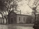
| Description: | Congregational church, organized in 1852. |

| Date: | 1880 |
|---|---|
| Description: | Exterior view of the Commercial Hotel. Horse-drawn vehicles are in front of the building. People are standing on the sidewalk in front. |
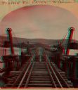
| Date: | 1873 |
|---|---|
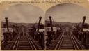
| Description: | Stereograph of John Lawler's pile-pontoon railway bridge over both channels of the Mississippi River at Prairie du Chien, and McGregor, Iowa. East draw, 39... |
| Date: | 1870 |
|---|---|
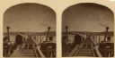
| Description: | Stereograph of John Lawler's pile-pontoon railway bridge over the Mississippi River. Three men are standing and sitting on the bridge in the foreground. Bu... |
| Date: | 1880 |
|---|---|
| Description: | Stereograph of an artesian well, located near the intersection of Wisconsin Street and South Minnesota Street (since renamed Wacouta). Construction was com... |

| Date: | 1878 |
|---|---|
| Description: | Illustrated map of Crawford County. On the bottom right is an inset of a group of people near a train on a railroad track. |
| Date: | 1870 |
|---|---|
| Description: | Stereograph of John Lawler's pile-pontoon railway bridge over the Mississippi River. |
| Date: | 1880 |
|---|---|
| Description: | Stereograph looking northeast from Case's Block. |

| Date: | 1830 |
|---|---|
| Description: | This early 19th century manuscript map of Prairie du Chien, Wisconsin, shows sections, landownership and acreages, roads, and ferries in the towns of Bridg... |
If you didn't find the material you searched for, our Library Reference Staff can help.
Call our reference desk at 608-264-6535 or email us at:
