Filter: Categories of Wisconsin Historical Images
Filter: County of Crawford
Filter: Subject of human settlements
Filter: Categories of Wisconsin Historical Images
Filter: County of Crawford
Filter: Subject of human settlements
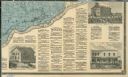
| Date: | 1878 |
|---|---|
| Description: | The bottom right corner of a map of Crawford County. This portion of the map includes town directories and illustrations of the Court House in Prairie Du C... |
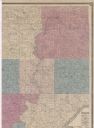
| Date: | 1878 |
|---|---|
| Description: | Portion of a map of Crawford County. |
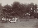
| Date: | 1898 |
|---|---|
| Description: | Dousman family entertaining house guests on the lawn at Villa Louis. A table and chairs are set up on the grass and several of the group are holding baseba... |

| Date: | 1900 |
|---|---|
| Description: | This map shows a line, marked with latitude and longitude coordinates that runs through Prairie du Chien. Only a few features beyond this line are displaye... |
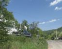
| Date: | 07 30 2012 |
|---|---|
| Description: | A view up a street, with a house and truck on the right. |
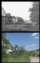
| Date: | |
|---|---|
| Description: | A vintage view and a modern view of the same location, presented as a pair. The vintage view includes a dirt road, several buildings, horses, and people. T... |

| Date: | 1900 |
|---|---|
| Description: | This photocopy map shows proposed buildings and building use at Fort Crawford. |

| Date: | 1900 |
|---|---|
| Description: | This photocopy map shows marshes, woods, buildings, and selected features including islands, mounds, old Fort Crawford, and "new site for a fort in questio... |
| Date: | 1930 |
|---|---|
| Description: | This photocopy map includes cross section of buildings. |

| Date: | 1942 |
|---|---|
| Description: | This photocopy plat map represents the relative position and size of the sloughs and islands in the Mississippi River, opposite Prairie du Chien. |

| Date: | 1900 |
|---|---|
| Description: | This photocopy map shows blocks, lots, subdivisions, city wards, buildings, some landownership, and the Mississippi River. The map margins include business... |

| Date: | 1839 |
|---|---|
| Description: | This map shows the geological makeup of the valley in red, yellow, and green, the Mississippi River, and the location of Fort Crawford. The geology on the ... |

| Date: | |
|---|---|
| Description: | View across field towards Villa Louis, with a white fence in the middle ground and a race track in the foreground. |
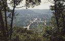
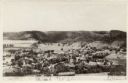
| Date: | 1918 |
|---|---|
| Description: | Elevated view of central Gays Mills. The school is in the lower left. A church is on the right. Caption reads: "Gays Mills, Looking East.: |
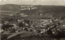
| Date: | |
|---|---|
| Description: | Elevated view of Gays Mills. A river is on the left, and there is a hill along the horizon. Caption reads: "View of Gays Mills, Wis." |
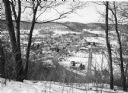
| Date: | 1982 |
|---|---|
| Description: | Bare trees frame an elevated view of Gays Mills taken from a snowy hilltop, showing Highway 131, lower right, as it curves into Main Street. Highway 171 en... |

| Date: | |
|---|---|
| Description: | View down street towards a crowd of people, sitting or standing on the side of the street, or on top of the buildings, watching a parade. A firetruck from ... |
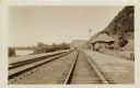
| Date: | |
|---|---|
| Description: | View down railroad tracks running along the Mississippi River past a depot. Men are walking near the depot. Caption reads: "C.B.&O. Yards, Lynxville, Wis." |
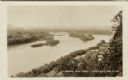
| Date: | |
|---|---|
| Description: | Elevated view of the Mississippi River at Lynxville. Railroad tracks are running alongside the shoreline. Caption reads: "Looking N.W. from Lynxville, Wis.... |
If you didn't find the material you searched for, our Library Reference Staff can help.
Call our reference desk at 608-264-6535 or email us at: