 Filter: Categories of Wisconsin Historical Images
Filter: County of Crawford
Filter: Subject of human settlements
Filter: Year of 1900-1999
Filter: Categories of Wisconsin Historical Images
Filter: County of Crawford
Filter: Subject of human settlements
Filter: Year of 1900-1999

| Date: | 1926 |
|---|---|
| Description: | View from hill looking down at homes and businesses in town. A bridge goes over the Kickapoo River. The depot and railroad tracks and Main Street are behin... |

| Date: | 1922 |
|---|---|
| Description: | View across yard of the public school, a one-story wood frame L-shaped building on a hill. There are groups of students standing on the stairs at the entra... |

| Date: | 1909 |
|---|---|
| Description: | View from the unpaved street of the Bank of Wauzeka, which is a small wood frame building with a large plate glass window. The sidewalk in front paved, and... |

| Date: | 1930 |
|---|---|
| Description: | View across road or path of St. Paul's Evangelical Lutheran Church, which is a wood frame building with a double door entrance with transom windows above, ... |

| Date: | 1930 |
|---|---|
| Description: | View up hill of the public school, which is a two-story wood frame building with a belfry in the center of the roof. Stairs lead to the arched entrance, an... |
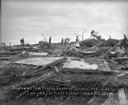
| Date: | 06 12 1915 |
|---|---|
| Description: | People standing among the broken remains of the Tim Finley farm after a killer tornado. A woman in the center is standing on a mattress. Two people were ki... |
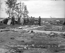
| Date: | 06 12 1915 |
|---|---|
| Description: | Group of men and boys standing around the exposed foundation of a house in the foreground. There is part of an overturned roof on the left. Broken wood is ... |

| Date: | 1909 |
|---|---|
| Description: | Photographic postcard view of a stone house with a group of people standing on the porch. Wood and barbed wire fencing is in the front yard. Caption reads:... |
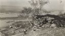
| Date: | 1915 |
|---|---|
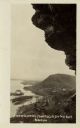
| Description: | Elevated view of the Mississippi River from a bluff. There is a farm and other houses along the shoreline, and in the foreground a boy stands on the bluff ... |
| Date: | 1912 |
|---|---|
| Description: | View along Main Street of shops, horses and townspeople. |

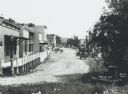
| Date: | 1909 |
|---|---|
| Description: | View from street of storefronts, Post Office and group of bystanders. |

| Date: | 01 15 1929 |
|---|---|
| Description: | Intended for tourists, this brochure, titled: "Winneshiek World’s Famous Wild Life Refuge Historic Fort Crawford and Picturesque Prairie du Chien," feature... |

| Date: | 1950 |
|---|---|
| Description: | Intended for tourists, this brochure features two maps with tourists sites along the Mississippi River. One map shows roads and populated places along the ... |

| Date: | 1976 |
|---|---|
| Description: | This map includes an index of streets, government and historic buildings, hospitals, schools, places of recreation, churches, cemeteries, and other miscell... |
| Date: | 1910 |
|---|---|
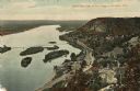
| Description: | Color enhanced aerial view of the village of DeSoto, looking north along the Mississippi River. Caption reads: "Bird's Eye View of the Village of De Soto, ... |
| Date: | 1920 |
|---|---|
| Description: | Black and white photographic postcard view of De Soto, taken from the cliff south of town, looking north along the Mississippi River. Caption reads: "A Vie... |

| Date: | 07 28 1934 |
|---|---|
| Description: | This map shows buildings and dimensions of Fort Crawford and hospital overlaid on a plat of existing lots, streets, and closed streets. |
| Date: | 1912 |
|---|---|
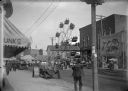
| Description: | View from sidewalk of a street carnival with tents, circus banners and a Ferris Wheel set up in the middle of the street. Signboards advertise ice cream an... |
| Date: | 1912 |
|---|---|
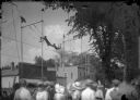
| Description: | View from crowd of a pair of trapeze acrobats performing at a street fair. |

| Date: | 1900 |
|---|---|
| Description: | This map shows a line, marked with latitude and longitude coordinates that runs through Prairie du Chien. Only a few features beyond this line are displaye... |
If you didn't find the material you searched for, our Library Reference Staff can help.
Call our reference desk at 608-264-6535 or email us at: