Filter: Categories of Wisconsin Historical Images
Filter: County of Crawford
Filter: Subject of botany
Filter: Creator Name of Unknown
Filter: Categories of Wisconsin Historical Images
Filter: County of Crawford
Filter: Subject of botany
Filter: Creator Name of Unknown
| Date: | |
|---|---|
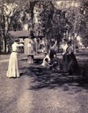
| Description: | Target shooting on the east lawn of Villa Louis. Nina S. Dousman is on the extreme right of the image. |

| Date: | 1905 |
|---|---|
| Description: | Elevated view of Soldiers' Grove with a bridge in the foreground. |
| Date: | 1920 |
|---|---|
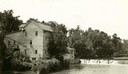
| Description: | A large building, possibly a mill, next to a river. |
| Date: | |
|---|---|
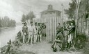
| Description: | Diorama in the Milwaukee Public Museum depicting Black Hawk's surrender on August 27, 1832 at Fort Crawford in Prairie du Chien. |
| Date: | 1880 |
|---|---|
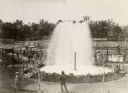
| Description: | Elevated view of Artesian Well, located near the intersection of Wisconsin Street and South Minnesota Street (since renamed Wacouta). It was dubbed by some... |
| Date: | 10 19 1911 |
|---|---|
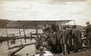
| Description: | Aviator Hugh Robinson and his Curtiss flying boat on the Mississippi River. |
| Date: | 10 19 1911 |
|---|---|
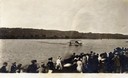
| Description: | A crowd gathered on the Mississippi River shoreline near Prairie du Chien. They are watching pioneer aviator Hugh Robinson taxi his Curtiss flying boat. |
| Date: | 1898 |
|---|---|
| Description: | Elevated view of the Kickapoo & Northern Railway locomotive and cars seen here after being derailed due to flooding on the Kickapoo River. |
| Date: | |
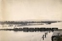
|---|---|
| Description: | Elevated view of the pile-pontoon railroad bridge across the Mississippi River at Prairie du Chien. The bridge was built and patented by John Lawler in 187... |
| Date: | 1900 |
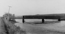
|---|---|
| Description: | View from road of a partially covered bridge. Industrial buildings are near the entrance to the bridge on the left. |

| Date: | 1895 |
|---|---|
| Description: | View down road with the Bay State House on the left. Three houses and a barbershop also line the street. A lamppost is in the left foreground. The Mississ... |

| Date: | 1902 |
|---|---|
| Description: | River with distant hills behind a town. An island is in the foreground. |
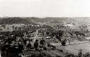
| Date: | 1946 |
|---|---|
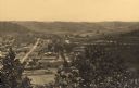
| Description: | Elevated view from hill of Gays Mills. Tree-covered hills are in the distance. |

| Date: | 1908 |
|---|---|
| Description: | Elevated view of Wauzeka. A bridge over a river is in the background. |
| Date: | |
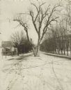
|---|---|
| Description: | The Black Hawk Tree growing in the middle of the street, now East Black Hawk Avenue. There are houses on the left and the road is lined with trees planted... |

| Date: | 1898 |
|---|---|
| Description: | View from water tower, showing the grove where Black Hawk's pursuers were supposed to have camped in 1832. The group of men in the foreground are digging f... |

| Date: | 1864 |
|---|---|
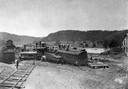
| Description: | Fort Crawford was decommissioned in 1856, having outlived its usefulness as a frontier post. During the Civil War, however, it functioned as a military ho... |

| Date: | |
|---|---|
| Description: | A man and woman golf on the west lawn of Villa Louis. They are probably members of the Dousman family. |
| Date: | 1915 |
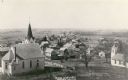
|---|---|
| Description: | Elevated view of the town with a church building in the left foreground. Caption reads: "Birds Eye View Mt Sterling, Wis." |
If you didn't find the material you searched for, our Library Reference Staff can help.
Call our reference desk at 608-264-6535 or email us at: