 Filter: Categories of Wisconsin Historical Images
Filter: County of Clark
Filter: Subject of cities and towns
Filter: Year of 1800-1899
Filter: Categories of Wisconsin Historical Images
Filter: County of Clark
Filter: Subject of cities and towns
Filter: Year of 1800-1899

| Date: | 1880 |
|---|---|
| Description: | Bird's-eye map of Neillsville, with inset. |
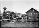
| Date: | 1882 |
|---|---|
| Description: | Group of men posing in front of the Wisconsin Central Railroad train at a depot. Railroad historian Roy L. Martin, from whose collection this image come... |

| Date: | 1896 |
|---|---|
| Description: | Exterior view of the Woodard home. The two-story house is made of brick and has black shutters framing the windows. There is a first and second story outdo... |
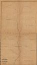
| Date: | 1873 |
|---|---|
| Description: | This 1873 map shows Clark County, Wisconsin, as well as the portion of Taylor County that was then part of Clark. The township and range grid, sections, ra... |

| Date: | 1880 |
|---|---|
| Description: | This 1880 map of Clark County, Wisconsin, shows the township and range grid, towns, sections, cities and villages, railroads, roads, rivers and lakes, dams... |
If you didn't find the material you searched for, our Library Reference Staff can help.
Call our reference desk at 608-264-6535 or email us at: