 Filter: Categories of Wisconsin Historical Images
Filter: County of Calumet
Filter: Subject of cities and towns
Filter: Categories of Wisconsin Historical Images
Filter: County of Calumet
Filter: Subject of cities and towns
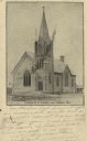
| Date: | 06 20 1907 |
|---|---|
| Description: | Black and white postcard of the German Methodist Episcopal Church. Caption reads: "German M.E. Church, near Brillion, Wis." |
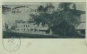
| Date: | 06 20 1907 |
|---|---|
| Description: | Postcard of North Main Street. Buildings line the right side of the street and there are several large trees along the sidewalk. Text below reads: "N. Main... |
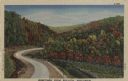
| Date: | 1947 |
|---|---|
| Description: | Colorized postcard of a paved road curving between hills with trees in autumn color. There are flowers in the fields on both sides of the road. Caption rea... |

| Date: | |
|---|---|
| Description: | Color postcard of a country road shaded by trees in autumn color. |

| Date: | |
|---|---|
| Description: | Color postcard of a man sitting on a stone wall along a road while enjoying a country scene. The road curves through the hills and the trees are starting t... |

| Date: | |
|---|---|
| Description: | Letterhead of the Chilton Branch of the Falk Jung & Borchert Brewing Company, headquartered in Milwaukee, Wisconsin. It includes, on the left, an elevated ... |

| Date: | 1977 |
|---|---|
| Description: | This 1977 map identifies the locations of 46 cemeteries in Calumet County, Wisconsin. Cemeteries are indexed by town. Also included are a civil town map, a... |
| Date: | 1943 |
|---|---|
| Description: | Map shows the town of St. Catherine, Wisconsin, between Lake Street and Doty Street as it appeared on January 3, 1852. Map is situated facing north with La... |
| Date: | 1863 |
|---|---|
| Description: | This plat map of Brillion is ink and pencil on paper. The front of the map shows a plat of the town, roads, and Spring Creek, and includes a significant ha... |
| Date: | 1836 |
|---|---|
| Description: | This plat map shows the proposed Town of Whitesboro, a paper city (a city planned but never built), located on the Manitowoc River in Calumet County. Certi... |

| Date: | 1836 |
|---|---|
| Description: | This negative photostat map shows the "oak tree, place of beginning" on the division line between Stockbridge and Brothertown Indians, and Governor Porter'... |

| Date: | 1974 |
|---|---|
| Description: | This map draws content from a map originally created by George Featherstongaugh in 1840. The map shows streets, land ownership, the Brotherton Indian reser... |

| Date: | 1909 |
|---|---|
| Description: | Hand-colored view of the Chilton Courthouse. A fence is along the sidewalk. Caption reads: "Court House, Chilton, Wis." |
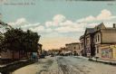
| Date: | 1907 |
|---|---|
| Description: | Hand-colored postcard view of the businesses along Main Street. Buggies are parked on the left. There is a circus poster on the right. Caption reads: "Main... |

| Date: | |
|---|---|
| Description: | Hand-colored street view of a business district. There is a three-story brownstone on the left, and horses and carts are in the street. Caption reads: "Low... |

| Date: | |
|---|---|
| Description: | Hand-colored view of the bridge and dam on the river in Chilton. Caption reads: "Bridge and Dam, Chilton, Wis." |

| Date: | 1914 |
|---|---|
| Description: | Hand-colored photomechanical view of a residential neighborhood with a large house on the corner. Trees line the street, and there is a windmill on the lef... |

| Date: | 1990 |
|---|---|
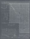
| Description: | This map includes two insets: Plat of New Holstein village and Village of Chilton. The map also includes a table of statistics showing the assessed value o... |
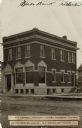
| Date: | 1908 |
|---|---|
| Description: | View of the State Bank, a two-story brick building on a street corner. Text on front reads: "T.E. Connell, President; John J. Sherman, Vice Pres.; John J. ... |

| Date: | 1912 |
|---|---|
| Description: | Three-quarter view of the front and side of a brick high school. There are a few students gathered in front. There is a church building in the background o... |
If you didn't find the material you searched for, our Library Reference Staff can help.
Call our reference desk at 608-264-6535 or email us at: