 Filter: Categories of Wisconsin Historical Images
Filter: County of Brown
Filter: Subject of water
Filter: Categories of Wisconsin Historical Images
Filter: County of Brown
Filter: Subject of water

| Date: | 1910 |
|---|---|
| Description: | Color enhanced view of the Fox River. Caption reads: "River Scene, De Pere, Wis." |

| Date: | 1920 |
|---|---|
| Description: | Looking at west De Pere from the east side. Shrubs and foliage are in the foreground. There are buildings and trees on the opposite shoreline. Caption read... |
| Date: | 1910 |
|---|---|
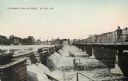
| Description: | View across river, with a man standing on the bridge on the right, looking at the government dam on the left. There is a sailing ship with three masts dock... |

| Date: | 1875 |
|---|---|
| Description: | Handwritten note on back identifies this elevated view as the west side of Broadway from National Bank, looking south. The Fox River is in the background o... |

| Date: | 1920 |
|---|---|
| Description: | Riverview Park on Fox River, with trees and shrubs. Caption reads: "Riverview Park on Fox River, De Pere, Wis." |

| Date: | 1910 |
|---|---|
| Description: | Photographic postcard of elevated view of the Wilcox Stone Mill, and part of Broadway showing the rear view of B.F. Smith's store below the hand-drawn arro... |
| Date: | 1910 |
|---|---|
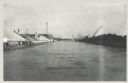
| Description: | Photographic postcard of elevated view of the back of mills lining the bridge. Coal kilns are below the hand-drawn arrow at top right. "Sawmills, gristmill... |
| Date: | 01 1935 |
|---|---|
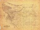
| Description: | This map shows landownership and acreages, additions to Green Bay, roads, railroads, East River, and Fox River. The bottom left of the map reads: "January ... |
| Date: | 12 16 1957 |
|---|---|
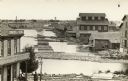
| Description: | View across water, with cranes among piles of coal along the right, and among piles of other materials on the left. Smoke is in the distance on the right, ... |

| Date: | 1963 |
|---|---|
| Description: | This blue line print shows as of March 1960 federal, state, county, and town roads, as well as railroads, schools, churches, town hall, parks, and Brown Co... |

| Date: | 1906 |
|---|---|
| Description: | This map shows streets, railroads, land use, public buildings, commercial businesses, and the Menominee River. Depths are shown by gradient tints and sound... |

| Date: | 1888 |
|---|---|
| Description: | This is a reproduction of a map originally published in 1829 by R.W. Chandler, a pioneer settler of Galena. It is based on an earlier map by surveyor Luciu... |

| Date: | 1907 |
|---|---|
| Description: | Sanborn map of Green Bay including St. George and Main Streets. |

| Date: | 1907 |
|---|---|
| Description: | Sanborn map of Green Bay featuring Elm, Cedar and Main Streets. |

| Date: | 1900 |
|---|---|
| Description: | This photostat map was probably originally created in 1835 and shows in addition to private claims, mills, roads, and trails. Green Bay and the Fox River a... |

| Date: | 1900 |
|---|---|
| Description: | This photocopied map shows private claim owners, buildings, and land use in 1818. Insets show Fort Howard and the caption reads: "A view of the Fox River ... |

| Date: | 1921 |
|---|---|
| Description: | This map shows various zones in a proposed city ordinance. Also shown are creeks, streets, parks, hospitals, cemeteries, and the Fox River. A legend is inc... |

| Date: | 1862 |
|---|---|
| Description: | This map shows landownership on a military reserve, private claims, buildings (including Fort Howard and U.S. sawmill), swamps, public barns and fields, an... |

| Date: | 1900 |
|---|---|
| Description: | This map shows land owners, railroads, and rivers. |

| Date: | 1965 |
|---|---|
| Description: | This map shows landownership, acreages, and roads. The city of De Pere, the town of Hobart, and the Fox River are labeled. Inset maps showing Smits Subdivi... |
If you didn't find the material you searched for, our Library Reference Staff can help.
Call our reference desk at 608-264-6535 or email us at: