 Filter: Categories of Wisconsin Historical Images
Filter: County of Brown
Filter: Subject of human settlements
Filter: Year of 1800-1899
Filter: Categories of Wisconsin Historical Images
Filter: County of Brown
Filter: Subject of human settlements
Filter: Year of 1800-1899

| Date: | 1874 |
|---|---|
| Description: | This map shows streets, buildings, railroads, the Fox River, the East River, and part of Green Bay. |

| Date: | 1875 |
|---|---|
| Description: | Handwritten note on back identifies this elevated view as the west side of Broadway from National Bank, looking south. The Fox River is in the background o... |

| Date: | 1862 |
|---|---|
| Description: | This map shows landownership on a military reserve, private claims, buildings (including Fort Howard and U.S. sawmill), swamps, public barns and fields, an... |

| Date: | 1850 |
|---|---|
| Description: | This map shows the location of planned blocks and lot numbers, street names, and docks along the Fox River and canal. |

| Date: | 1850 |
|---|---|
| Description: | This photocopied map shows lot and block numbers, selected buildings, street names and state lock located on the Fox River. Includes a description of Deper... |

| Date: | 1835 |
|---|---|
| Description: | Map shows the Fox River, lot and block numbers, private claims, streets, a public squares, a manual labour school, and Fort Howard. An inset map shows a pl... |

| Date: | 1851 |
|---|---|
| Description: | Elevated view across water towards Fort Howard. In the foreground is a man standing on a pier, and in the water nearby are five men rowing in a boat. Capti... |
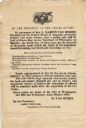
| Date: | 1838 |
|---|---|
| Description: | Broadside advertising the public sale of land at Green Bay, issued by Martin Van Buren. |
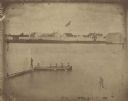
| Date: | 1851 |
|---|---|
| Description: | A rare photograph of U.S. Army soldiers stationed at Fort Howard rowing a boat on the Fox River. Fort Howard, built in 1816, was the first in the chain of ... |

| Date: | 1870 |
|---|---|
| Description: | Elevated view of an unpaved main street, with the Village House across the street in the center background. Wooden buildings and wooden sidewalks are on bo... |

| Date: | 1875 |
|---|---|
| Description: | Elevated view of several buildings, with bridge and railroad tracks, and the Fox River. In the foreground on the right is the Commercial House, with three ... |
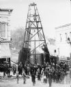
| Date: | 1885 |
|---|---|
| Description: | Elevated view of a crowd of people standing near an artesian well. Men wearing long coats and hats to protect them from the water are standing on and unde... |
If you didn't find the material you searched for, our Library Reference Staff can help.
Call our reference desk at 608-264-6535 or email us at:
