 Filter: Categories of Wisconsin Historical Images
Filter: County of Bayfield
Filter: Year of 1900-1999
Filter: Subject of transportation
Filter: Categories of Wisconsin Historical Images
Filter: County of Bayfield
Filter: Year of 1900-1999
Filter: Subject of transportation

| Date: | 1971 |
|---|---|
| Description: | A topographical map of Namekagon Lake and the surrounding area. |
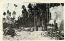
| Date: | 1920 |
|---|---|
| Description: | View across snowy ground towards a steam-belching train engine on the right pulling flatbeds of stacked logs near a forest of tall pines. Caption reads: "L... |
| Date: | 1920 |
|---|---|
| Description: | View across railroad tracks towards train flatbeds stacked with large pine logs. There is a man standing further down the tracks looking towards the flatbe... |
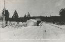
| Date: | 1935 |
|---|---|
| Description: | Winter scene with a V-blade snowplow from the front plowing snow from a road. The snow is billowing to the left side of the road in a large arc. Trees are... |
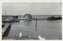
| Date: | 06 19 1958 |
|---|---|
| Description: | Slightly elevated view of Cornucopia Harbor. There is a boat moored at a pier near a barn-shaped building. An automobile is parked on the far left. In the ... |
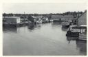
| Date: | 06 19 1958 |
|---|---|
| Description: | Slightly elevated view over water towards East slip in Cornucopia Harbor. There is a small cluster of buildings along the left and right sides with boats m... |
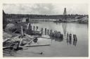
| Date: | 06 19 1958 |
|---|---|
| Description: | View over water towards storm damage in Cornucopia Harbor. West slip. There is a pile of wood along the shoreline in the foreground, with a boat moored jus... |
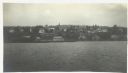
| Date: | 1916 |
|---|---|
| Description: | View across Lake Superior towards Bayfield. |

| Date: | 1935 |
|---|---|
| Description: | This topographical map of the forest preserve shows highways, roads, trails, telephone lines, Native American reservations, Ranger sub-stations, state nurs... |

| Date: | 1912 |
|---|---|
| Description: | This map shows a school reserve, swamp land, railroads, and selected buildings. |

| Date: | 1918 |
|---|---|
| Description: | Manuscript map of the Chequamegon Bay area on Lake Superior drawn by Warren W. Witmer and illustrated with sketches by Mary L. Wright Witmer in ink and wat... |

| Date: | 1990 |
|---|---|
| Description: | This map shows various types of trails, boat landings, canoe areas, public beaches, picnic areas, campgrounds, golf courses, public tennis courts, and othe... |

| Date: | 1929 |
|---|---|
| Description: | Aerial view of Lake Namakagon, showing the roads that connect Anderson Island (center left), and Juneks Point, Eagle Point, and Paines Island. |
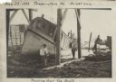
| Date: | 11 29 1908 |
|---|---|
| Description: | Men working on pulling the boat "Fish Hawk" out of the water. One man is kneeling in front of the boat and looking at the camera. A man in the background i... |

| Date: | 1924 |
|---|---|
| Description: | A school bus pulled by a team of horses named Colonel and Ned. |
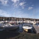
| Date: | 10 1978 |
|---|---|
| Description: | View from shoreline towards motorboats and sailboats docked in a marina. In the distance are buildings on a hill among trees. |
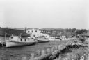
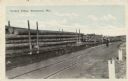
| Date: | 07 1936 |
|---|---|
| Description: | Fishing tugs are moored alongside the wharf at Bayfield. The large Bayfield Fish Co. building is identified in large letters on the end of the building. Th... |
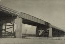
| Date: | 1948 |
|---|---|
| Description: | The U.S. Highway 2 overpass spans two sets of railroad tracks that cross beneath at Ashland Junction. One railroad line belongs to the Northern Pacific Rai... |
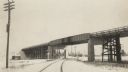
| Date: | 1948 |
|---|---|
| Description: | The U.S. Highway 2 overpass spans two sets of railroad tracks that cross beneath at Ashland Junction. One railroad line belongs to the Northern Pacific Rai... |

| Date: | 1904 |
|---|---|
| Description: | View overlooking Iron River in winter. Several residences, and yards with fences are in the foreground. Wooded hills are in the far background. |
If you didn't find the material you searched for, our Library Reference Staff can help.
Call our reference desk at 608-264-6535 or email us at: