Filter: Categories of Wisconsin Historical Images
Filter: County of Bayfield
Filter: Year of 1900-1999
Filter: Subject of education
Filter: Categories of Wisconsin Historical Images
Filter: County of Bayfield
Filter: Year of 1900-1999
Filter: Subject of education

| Date: | 1910 |
|---|---|
| Description: | Bird's-eye view looking east, with Washburn Harbor at center and Chequamegon Bay in Lake Superior covering most of the upper image. Streets with buildings... |
| Date: | 1920 |
|---|---|
| Description: | View of Ondossagon, a consolidated school. View across lawn towards a large group of people standing near horses in front of the building. |
| Date: | 1920 |
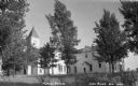
|---|---|
| Description: | View across lawn towards the school building. Caption reads: "High School Building, Washburn, Wis." |
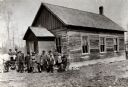
| Date: | 1906 |
|---|---|
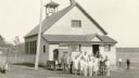
| Description: | Exterior view of the Raspberry School with a group of adults and children standing outside its entrance. |

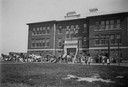
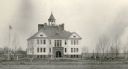
| Date: | 1930 |
|---|---|
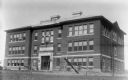
| Description: | Exterior view of the Washburn High School, a two-story cut stone building with an attic and raised basement in the Romanesque architectural style. There is... |
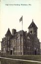
| Date: | 1940 |
|---|---|
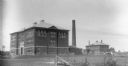
| Description: | View of the Ondossagon Public School building. The three-story brick structure was built in 1917. In the background are other brick additions and another t... |
| Date: | 1940 |
|---|---|
| Description: | Exterior view of the Ondossagon Public School building. This three-story brick structure was built in 1917. |
| Date: | 1935 |
|---|---|
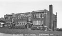
| Description: | Exterior view of a two-story brick building, the Drummond High School. There is some decoration around the windows, front doors, and in the brickwork. The ... |

| Date: | 1900 |
|---|---|
| Description: | This 1900 map shows the township and range system, sections, cities and villages, railroads, roads, vacant land and land sold by the Wisconsin Central Rail... |

| Date: | 1917 |
|---|---|
| Description: | This map, which highlights the land for sale by the Rust-Owen Lumber Company in the towns of Drummond, Cable and Grandview, Bayfield County, Wisconsin, sho... |

| Date: | 1906 |
|---|---|
| Description: | This 1906 map of Bayfield County, Wisconsin, shows towns, sections, cities, villages and post offices, land ownership, wagon roads, railroads, schools, gov... |

| Date: | 1967 |
|---|---|
| Description: | This tourist brochure for Bayfield County, Wisconsin, from 1967 includes a map of the county showing towns, cities and villages, highways and roads, railro... |
| Date: | 1931 |
|---|---|
| Description: | Pupils and their teacher (rear) pose in front of their school house. Two cars are parked in the school yard. A man and other pupils stand near a water pump... |
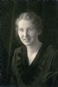
| Date: | 1930 |
|---|---|
| Description: | Quarter-length studio portrait of Inez Lindell Bystrom, teacher at Miles School in the town of Orienta in Bayfield County. Mrs. Bystrom was born in Lulea, ... |
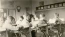
| Date: | 1931 |
|---|---|
| Description: | Students of the Miles School, Bayfield County District No. 2, read at their desks supervised by their teacher, Mrs. Inez Lindell Bystrom. There is a parlor... |
| Date: | 1931 |
|---|---|
| Description: | Children play on swings in front of the imposing Port Wing Consolidated School. It is two stories tall, with wood frame construction, a tall sandstone foun... |

| Date: | 1931 |
|---|---|
| Description: | A girl posing at the side of the Miles District No. 2 School. Selected as the "girl 4-H champion," Emilie, age 12, was noted by her teacher as "an outstand... |

| Date: | 1910 |
|---|---|
| Description: | This map is ink and pen on tracing cloth and shows plat of the town, local streets, county roads, railroads, school houses, town halls, hotels, sheds, barn... |

| Date: | 1919 |
|---|---|
| Description: | This map is a topographical map and has relief shown by contours. The map shows roads, state highways, hotels, town halls, school houses, stores, barns, de... |
If you didn't find the material you searched for, our Library Reference Staff can help.
Call our reference desk at 608-264-6535 or email us at: