 Filter: Categories of Wisconsin Historical Images
Filter: County of Bayfield
Filter: Subject of water
Filter: Categories of Wisconsin Historical Images
Filter: County of Bayfield
Filter: Subject of water

| Date: | |
|---|---|
| Description: | View of the sun shining through clouds over a lake, identified as Lake Namakagon. In the foreground are some rocks on the shoreline, and more trees are vis... |

| Date: | |
|---|---|
| Description: | View of the sun shining through clouds over a lake, either Jackson Lake or Lake Namakagan. In the foreground are some trees, and more trees are visible on ... |
| Date: | |
|---|---|
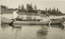
| Description: | View of a man paddling a canoe with a woman sitting in the front holding an umbrella and white water lily. The canoe says "Nature Lovers Paradise." Text de... |

| Date: | 1858 |
|---|---|
| Description: | Front cover of a guide book describing Bayfield and an account of a pleasure tour to Lake Superior. The title is surrounded by a decorative border with flo... |

| Date: | 1934 |
|---|---|
| Description: | View across lake of three cottages surrounded by trees. Each cottage has a screened porch and a dock on the shore of Cable Lake. There is a group of childr... |

| Date: | 1930 |
|---|---|
| Description: | View of a pile of fish on a stringer lying in the grass, these fish may have been caught on Lake Namakagon. A person's hand appears at the top, holding the... |

| Date: | 1933 |
|---|---|
| Description: | View looking down tree-lined road and birch log fence. The road is along a shoreline and leads to the Lakewoods Country Club. Three buildings are along a l... |
| Date: | 1931 |
|---|---|
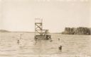
| Description: | View across water of men and children swimming around and diving off of a diving platform at Lakewoods Resort on Namakagon Lake. In the distance is the far... |

| Date: | 1931 |
|---|---|
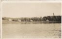
| Description: | Scenic view from shoreline over Namakagon Lake towards the opposite shoreline. There are two large buildings nestled among trees with a pergola on the lawn... |

| Date: | 1934 |
|---|---|
| Description: | View from water towards shoreline of two boats at Les Crandall's Housekeeping Cottages on Lake Namakagon tied up in front of two log cabins. A deer (not kn... |
| Date: | 1935 |
|---|---|
| Description: | View across lake towards four single-story cabins with front porches along the shoreline of Lyndale Bay on Eau Claire Lakes. |
| Date: | 1932 |
|---|---|
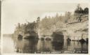
| Description: | Lake view of Apostle Islands sandstone caves along the shores of Lake Superior. |

| Date: | 1935 |
|---|---|
| Description: | House, cottages and property of Mrs. J.J. Fisher overlooking Lake Superior. |

| Date: | 1880 |
|---|---|
| Description: | This copy of an 1834 map in the American Fur Company's papers held by the New-York Historical Society shows an outline of Chequamegon Bay and Madeline Isla... |

| Date: | 1900 |
|---|---|
| Description: | This 1900 map shows the township and range system, sections, cities and villages, railroads, roads, vacant land and land sold by the Wisconsin Central Rail... |

| Date: | 1871 |
|---|---|
| Description: | Asaph Whittlesey arrived in Ashland in 1854, one of the earliest of the settlers who hoped the area would grow and make their fortunes. He drew this map of... |

| Date: | 1952 |
|---|---|
| Description: | This 1952 map of the northern parts of Bayfield and Douglas counties, Wisconsin, shows points established by E.T. Sweet in 1877, road points confirmed by S... |

| Date: | 1952 |
|---|---|
| Description: | This map of the northern parts of the Chequamegon Bay area in Bayfield and Ashland counties, Wisconsin, shows trails, roads, railroads, stations, the towns... |

| Date: | 1917 |
|---|---|
| Description: | This map, which highlights the land for sale by the Rust-Owen Lumber Company in the towns of Drummond, Cable and Grandview, Bayfield County, Wisconsin, sho... |

| Date: | 1917 |
|---|---|
| Description: | This 1917 map of Bayfield County, Wisconsin, shows the township and range system, towns, sections, cities and villages, railroads, wagon roads, and lakes a... |
If you didn't find the material you searched for, our Library Reference Staff can help.
Call our reference desk at 608-264-6535 or email us at: