 Filter: Categories of Wisconsin Historical Images
Filter: County of Bayfield
Filter: Subject of mines and mineral resources
Filter: Categories of Wisconsin Historical Images
Filter: County of Bayfield
Filter: Subject of mines and mineral resources

| Date: | 1952 |
|---|---|
| Description: | This 1952 map of the northern parts of Bayfield and Douglas counties, Wisconsin, shows points established by E.T. Sweet in 1877, road points confirmed by S... |
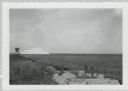
| Date: | |
|---|---|
| Description: | View from shoreline of dock site towards Lake Superior, showing sulphur pile and a large chute in the background. |
If you didn't find the material you searched for, our Library Reference Staff can help.
Call our reference desk at 608-264-6535 or email us at: