 Filter: Categories of Wisconsin Historical Images
Filter: County of Ashland
Filter: Year of 1800-1899
Filter: Categories of Wisconsin Historical Images
Filter: County of Ashland
Filter: Year of 1800-1899

| Date: | 1850 |
|---|---|
| Description: | Map is pen and pencil on paper. The map shows roads, creeks, and the Chequamegon Bay. The map is undated and prepared sometime between the establishment of... |

| Date: | 09 04 1885 |
|---|---|
| Description: | Exterior and interior bill of fare from The Chequamegon, with views on the back of rock formations, waterfalls, a spot illustration of a train going over a... |

| Date: | 1888 |
|---|---|
| Description: | This map shows wards and includes the Chequamegon Bay and Washburn. An inset map shows the Ashland region, its railroads, and a few of its iron mines. |
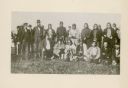
| Date: | 1852 |
|---|---|
| Description: | Group portrait of members of the La Pointe Band (now known as the Bad River La Pointe Band) of the Ojibwe Nation awaiting annuity payment at La Pointe. Non... |

| Date: | 1886 |
|---|---|
| Description: | This map shows north and south ore veins, landownership, railroads, rivers, and township grid in parts of Ashland County, Wis. and Ontonagon County, Mich. ... |
| Date: | 1858 |
|---|---|
| Description: | This map shows drainage, acreages, and timber in the area now part of the Town of Shanagolden. The map includes a survey table, a meanders table, and certi... |
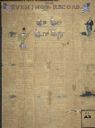
| Date: | 03 15 1896 |
|---|---|
| Description: | Page one of "Evening Record." The handwritten newspaper includes several hand-drawn color illustrations. Beginning in the top left corner, the illustration... |
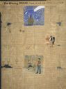
| Date: | 03 15 1896 |
|---|---|
| Description: | Page two of the "Evening Record." The handwritten newspaper includes several hand-drawn illustrations. On the top center of the page, one illustration port... |

| Date: | 1895 |
|---|---|
| Description: | Stereograph of the side cliff view of the railroad White River bridge, showing the support beams and river underneath. It is six miles south of Ashland. Th... |

| Date: | 1866 |
|---|---|
| Description: | Stereograph of an Ojibwa woman sitting on an overturned canoe with a baby on her back wrapped in a blanket. A young child is sitting at her feet. They are ... |
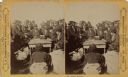
| Date: | 1870 |
|---|---|
| Description: | Ojibwa Indians receiving annuity payment. Seated on the right is John W. Bell. Others are, left to right, Asaph Whittlesey, Agent Henry C. Gilbert, and Wil... |
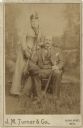
| Date: | 06 19 1890 |
|---|---|
| Description: | Studio portrait in front of a painted backdrop of a woman and man posing together. The man is sitting in a chair holding a hat and an umbrella. The woman i... |
If you didn't find the material you searched for, our Library Reference Staff can help.
Call our reference desk at 608-264-6535 or email us at:
