 Filter: Categories of Wisconsin Historical Images
Filter: County of Ashland
Filter: Subject of transportation
Filter: Subject of church buildings
Filter: Categories of Wisconsin Historical Images
Filter: County of Ashland
Filter: Subject of transportation
Filter: Subject of church buildings
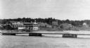
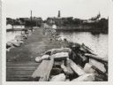
| Date: | 1920 |
|---|---|
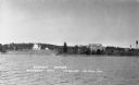
| Description: | View from the water of the Mission, dock, Mission cottages, and Congregational Church on Madeline Island. |
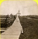
| Date: | 1870 |
|---|---|
| Description: | Boardwalk leading to St. Joseph's Catholic Church in La Pointe. |
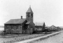
| Date: | |
|---|---|
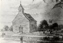
| Description: | Exterior view of Presbyterian Church with dirt path in front and wooden buildings in the background. |
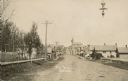
| Date: | 1910 |
|---|---|
| Description: | View of Main Street when it was a dirt road. A church is in the background, and telephone poles are along the left side of the road. A streetlight is hangi... |

| Date: | 1905 |
|---|---|
| Description: | View down road, with homes in a residential area, and a church building in the foreground on the right. The sign above the church door reads: "E. V. Luth. ... |
| Date: | 1870 |
|---|---|
| Description: | One of the etchings published in an atlas of Lake County, Illinios in 1870 by George Ogle. Etchings done by the Wisconsin Central Railroad. |

| Date: | 1842 |
|---|---|
| Description: | American Fur Company with both Mission churches. Sketch purportedly by a Native American youth. Probably an overpainted photographic copy enlargement. Pape... |
| Date: | 02 12 1912 |
|---|---|
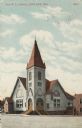
| Description: | Exterior view of the one-story, white First Methodist Church with double door entrance. |

| Date: | |
|---|---|
| Description: | Exterior view of St. Agnes Church, on the left, and school, on the right. Cars line the street along Lake Shore Drive in front of the buildings. |
| Date: | 1937 |
|---|---|
| Description: | View from the lake of the summer homes on Nebraska Row along the shoreline of Lake Superior. The water tower and church steeple are visible on the far righ... |
| Date: | 1932 |
|---|---|
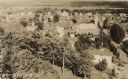
| Description: | Aerial view of town looking down from hill lined with trees. In the foreground railroad tracks cross a road. A church building and numerous dwellings are a... |

| Date: | 1896 |
|---|---|
| Description: | This 1896 map shows the township and range system, sections, cities and villages, railroads, roads, vacant land and land sold by the Wisconsin Central Rail... |

| Date: | 1890 |
|---|---|
| Description: | This 1890s map shows the Wisconsin Central Railroad land grant lands owned and for sale by the Soo Line in Ashland County, Wisconsin, as well as in the eas... |

| Date: | 1900 |
|---|---|
| Description: | This map is shows land in white and water in blue and is indexed for parks, points of interest, schools, churches, and recreational areas. The map shows lo... |
| Date: | 09 14 1962 |
|---|---|
| Description: | View from pier, lined with rocks, towards town. There are industrial buildings along the shoreline, and up a small rise is a building with a tower, and on ... |

| Date: | 1915 |
|---|---|
| Description: | This map shows school houses, churches, farms, and railroads. Chequamecon Bay and Bad River Indian Reservation are labeld. The map reads: "All lands shown ... |

| Date: | 1909 |
|---|---|
| Description: | This map shows vacant Wisconsin Central Ry. lands, settlers houses, lands sold by Wisconsin Central Ry., schools, churches, saw mills, and roads; also show... |
If you didn't find the material you searched for, our Library Reference Staff can help.
Call our reference desk at 608-264-6535 or email us at:
