 Filter: Categories of Wisconsin Historical Images
Filter: County of Ashland
Filter: Subject of transportation
Filter: Community of Ashland
Filter: Categories of Wisconsin Historical Images
Filter: County of Ashland
Filter: Subject of transportation
Filter: Community of Ashland
| Date: | 1939 |
|---|---|
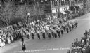
| Description: | Elevated view of students from the Hurley High School Band marching in a parade at the Music Festival, on Main Street. Students are playing instruments inc... |
| Date: | 1939 |
|---|---|
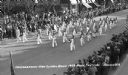
| Description: | Elevated view of students from the Ondossagon High School Band marching in a parade at the Music Festival, on Main Street. Students are wearing marching ba... |
| Date: | 1930 |
|---|---|
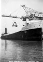
| Description: | View of the ship "Alex B. Uhrig" in the process of coal unloading on the Reiss Coal Dock No. 2. |
| Date: | 1933 |
|---|---|
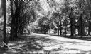
| Description: | View looking down Third Street East. There are large trees lining both sides of the street. One automobile is parked along the curb on the left, and a few ... |
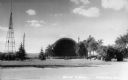
| Date: | 1935 |
|---|---|
| Description: | View of the Ashland Band Shell with benches, trees, and what is today Highway 2 in the foreground. On the left is a large metal tower, and in the backgroun... |

| Date: | 1930 |
|---|---|
| Description: | Exterior view of Hotel Menard, a three-story building with what appears to be brick and wood siding. Looking down Main Street West, what used to be called ... |
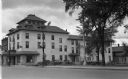
| Date: | 1939 |
|---|---|
| Description: | Exterior view of Hotel Menard, a three-story building with what appears to be stucco exterior. There is a front entrance with what appears to be stonework ... |
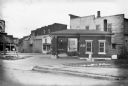
| Date: | 1935 |
|---|---|
| Description: | View of a small brick building, probably a service station, with the word "AIR" painted on the bricks, on the south east corner of 9th Ave. West and 2nd St... |

| Date: | |
|---|---|
| Description: | Aerial view of town, showing the shoreline of Lake Superior, ore docks, roads, houses, buildings, trees, and smokestacks. Text describing this photograph s... |

| Date: | 1978 |
|---|---|
| Description: | A student using an engine lathe in an auto mechanics class at Indianhead Technical Institute. He is wearing safety glasses, jeans and an Ashland wrestling ... |
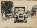
| Date: | 1926 |
|---|---|
| Description: | Front view of a truck decorated for a parade. Manufactured by the White Motor Company, used as a Bamby Bread delivery truck. |
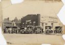
| Date: | 1928 |
|---|---|
| Description: | Six trucks and a car are parked in front of the Central Baking Company. Most of the vehicles are decorated with flags and streamers for a parade. The truck... |

| Date: | 1952 |
|---|---|
| Description: | This 1952 map shows the trails, roads, and railroads through the counties of Ashland, Bayfield, Sawyer, Price, Iron, and Vilas. Also shown are lakes, river... |

| Date: | 1887 |
|---|---|
| Description: | This 1887 map of Ashland County, Wisconsin, shows the township and range system, sections, railroads, vacant Wisconsin Central Railroad land, state and "go... |

| Date: | 1896 |
|---|---|
| Description: | This 1896 map shows the township and range system, sections, cities and villages, railroads, roads, vacant land and land sold by the Wisconsin Central Rail... |

| Date: | 1896 |
|---|---|
| Description: | This 1898 map shows the township and range system, sections, cities and villages, railroads, roads, vacant land and land sold by the Wisconsin Central Rail... |
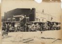
| Date: | 1928 |
|---|---|
| Description: | Six trucks and a car are parked in front of the Central Baking Company building. Most of the vehicles are decorated with flags and streamers for a parade. ... |

| Date: | 1908 |
|---|---|
| Description: | Title at top: "G.F. Sanborn Company Timber and Farming Lands." Map shows acreages, roads, railroads, and swamps in parts of Vilas and Oneida counties. |

| Date: | 1850 |
|---|---|
| Description: | Map is pen and pencil on paper. The map shows roads, creeks, and the Chequamegon Bay. The map is undated and prepared sometime between the establishment of... |

| Date: | 09 04 1885 |
|---|---|
| Description: | Exterior and interior bill of fare from The Chequamegon, with views on the back of rock formations, waterfalls, a spot illustration of a train going over a... |
If you didn't find the material you searched for, our Library Reference Staff can help.
Call our reference desk at 608-264-6535 or email us at: