 Filter: Categories of Wisconsin Historical Images
Filter: County of Ashland
Filter: Community of Ashland
Filter: Categories of Wisconsin Historical Images
Filter: County of Ashland
Filter: Community of Ashland

| Date: | 1978 |
|---|---|
| Description: | Teacher Dorothy Ledin teaching numbers to two pre-schoolers using a board with removable numbers and dots at Ellis School. |

| Date: | 1978 |
|---|---|
| Description: | A student using an engine lathe in an auto mechanics class at Indianhead Technical Institute. He is wearing safety glasses, jeans and an Ashland wrestling ... |

| Date: | 1978 |
|---|---|
| Description: | Congressman David R. Obey of Wisconsin (center) holding a press conference about federal funding for education with students at Ellis School. A few journal... |
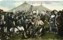
| Date: | 1896 |
|---|---|
| Description: | Colored postcard view of "Buffalo Bill" Cody center right in white coat and hat surrounded by Native Americans in traditional garb, military personnel and ... |
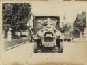
| Date: | 1926 |
|---|---|
| Description: | Front view of a truck decorated for a parade. Manufactured by the White Motor Company, used as a Bamby Bread delivery truck. |
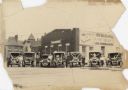
| Date: | 1928 |
|---|---|
| Description: | Six trucks and a car are parked in front of the Central Baking Company. Most of the vehicles are decorated with flags and streamers for a parade. The truck... |

| Date: | 1952 |
|---|---|
| Description: | This 1952 map shows the trails, roads, and railroads through the counties of Ashland, Bayfield, Sawyer, Price, Iron, and Vilas. Also shown are lakes, river... |

| Date: | 1887 |
|---|---|
| Description: | This 1887 map of Ashland County, Wisconsin, shows the township and range system, sections, railroads, vacant Wisconsin Central Railroad land, state and "go... |

| Date: | 1896 |
|---|---|
| Description: | This 1896 map shows the township and range system, sections, cities and villages, railroads, roads, vacant land and land sold by the Wisconsin Central Rail... |

| Date: | 1896 |
|---|---|
| Description: | This 1898 map shows the township and range system, sections, cities and villages, railroads, roads, vacant land and land sold by the Wisconsin Central Rail... |
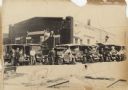
| Date: | 1928 |
|---|---|
| Description: | Six trucks and a car are parked in front of the Central Baking Company building. Most of the vehicles are decorated with flags and streamers for a parade. ... |

| Date: | 1989 |
|---|---|
| Description: | At the dedication of the Blue Cross/Blue Shield facilty, Congressman David R. Obey was present to present a flag that had flown over the United States Capi... |

| Date: | 1908 |
|---|---|
| Description: | Title at top: "G.F. Sanborn Company Timber and Farming Lands." Map shows acreages, roads, railroads, and swamps in parts of Vilas and Oneida counties. |

| Date: | 1800 |
|---|---|
| Description: | The map is ink and pencil on paper. Map shows the location of the Ashland Lumber Company as well as a portion of Ashland County. Portions of the map are in... |

| Date: | 1850 |
|---|---|
| Description: | Map is pen and pencil on paper. The map shows roads, creeks, and the Chequamegon Bay. The map is undated and prepared sometime between the establishment of... |

| Date: | 09 04 1885 |
|---|---|
| Description: | Exterior and interior bill of fare from The Chequamegon, with views on the back of rock formations, waterfalls, a spot illustration of a train going over a... |
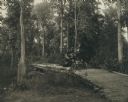
| Date: | |
|---|---|
| Description: | Dr. W.T. Rinehart, a prominent Ashland physician and surgeon, with Mrs. Rinehart and a sister, in an automobile crossing a small log bridge, probably over ... |

| Date: | 1931 |
|---|---|
| Description: | This map of Ashland shows roads, railroads, and local businesses. The map reads: "Showing streets and roads open to the public Oct. 1, 1931." Included on t... |

| Date: | 1947 |
|---|---|
| Description: | This map of Ashland is a cadastral map showing some rural landowners and includes index to points of interest. The map shows roads, railroads, parks, cemet... |

| Date: | 1951 |
|---|---|
| Description: | This map shows Ashland and Washburn harbors in shades of blue and yellow. Water depths shown by isolines and soundings, and relief is shown by contours. Th... |
If you didn't find the material you searched for, our Library Reference Staff can help.
Call our reference desk at 608-264-6535 or email us at: