 Filter: Categories of Wisconsin Historical Images
Filter: County of Ashland
Filter: Creator Name of Unknown
Filter: Categories of Wisconsin Historical Images
Filter: County of Ashland
Filter: Creator Name of Unknown

| Date: | 1978 |
|---|---|
| Description: | Teacher Dorothy Ledin teaching numbers to two pre-schoolers using a board with removable numbers and dots at Ellis School. |

| Date: | 1978 |
|---|---|
| Description: | A student using an engine lathe in an auto mechanics class at Indianhead Technical Institute. He is wearing safety glasses, jeans and an Ashland wrestling ... |

| Date: | 1978 |
|---|---|
| Description: | Congressman David R. Obey of Wisconsin (center) holding a press conference about federal funding for education with students at Ellis School. A few journal... |
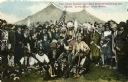
| Date: | 1896 |
|---|---|
| Description: | Colored postcard view of "Buffalo Bill" Cody center right in white coat and hat surrounded by Native Americans in traditional garb, military personnel and ... |

| Date: | 1834 |
|---|---|
| Description: | This copy of an 1834 map in the American Fur Company's papers held by the New-York Historical Society shows an outline of Chequamegon Bay and Madeline Isla... |

| Date: | 1890 |
|---|---|
| Description: | This map shows the Wisconsin Central Railroad land grant lands owned and for sale by the Soo Line in Ashland County, Wisconsin, as well as in portions of B... |

| Date: | 1949 |
|---|---|
| Description: | This 1949 map shows the topography and significant landmarks in Copper Falls State Park, Ashland County, Wisconsin. |

| Date: | 1949 |
|---|---|
| Description: | This 1949 map shows the topography and significant landmarks in Copper Falls State Park, Ashland County, Wisconsin. On the verso is a black-and-white image... |

| Date: | 1890 |
|---|---|
| Description: | This 1890s map shows the Wisconsin Central Railroad land grant lands owned and for sale by the Soo Line in Ashland County, Wisconsin, as well as in the eas... |
| Date: | 1915 |
|---|---|
| Description: | Exterior view of Hull Cottage, also known as Coole Park Manor, on Madeline Island. |

| Date: | 1989 |
|---|---|
| Description: | At the dedication of the Blue Cross/Blue Shield facilty, Congressman David R. Obey was present to present a flag that had flown over the United States Capi... |

| Date: | 1800 |
|---|---|
| Description: | The map is ink and pencil on paper. Map shows the location of the Ashland Lumber Company as well as a portion of Ashland County. Portions of the map are in... |

| Date: | 1850 |
|---|---|
| Description: | Map is pen and pencil on paper. The map shows roads, creeks, and the Chequamegon Bay. The map is undated and prepared sometime between the establishment of... |
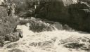
| Date: | 1931 |
|---|---|
| Description: | A group of people stand on a ledge overlooking Copper Falls. |

| Date: | 1931 |
|---|---|
| Description: | This map of Ashland shows roads, railroads, and local businesses. The map reads: "Showing streets and roads open to the public Oct. 1, 1931." Included on t... |

| Date: | 1924 |
|---|---|
| Description: | This map is pen, pencil, and watercolor on paper and shows land ownership by name, local streets, railroads, and part of Chequamegon Bay. The map includes ... |

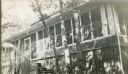
| Date: | 1929 |
|---|---|
| Description: | Exterior view of the building under construction, with two men working on the side of the log building on wooden scaffolds. This is probably on the site of... |

| Date: | 1988 |
|---|---|
| Description: | Congressman David Obey and his wife Joan on Martin Hanson's pontoon. He was a good friend of the Obeys and was inducted into the Wisconsin Conservation Hal... |
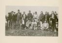
| Date: | 1852 |
|---|---|
| Description: | Group portrait of members of the La Pointe Band (now known as the Bad River La Pointe Band) of the Ojibwe Nation awaiting annuity payment at La Pointe. Non... |
If you didn't find the material you searched for, our Library Reference Staff can help.
Call our reference desk at 608-264-6535 or email us at:
