 Filter: Categories of Wisconsin Historical Images
Filter: Community of Waupun
Filter: Type of Map or Atlas
Filter: Subject of cities and towns
Filter: Creator Name of Unknown
Filter: Categories of Wisconsin Historical Images
Filter: Community of Waupun
Filter: Type of Map or Atlas
Filter: Subject of cities and towns
Filter: Creator Name of Unknown
| Date: | 1898 |
|---|---|
| Description: | This is a map of Waupun in 1898 that shows labeled streets, railroads, and the location of the state prison. There are annotations on the map in what appea... |

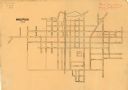
| Date: | 03 25 1931 |
|---|---|
| Description: | This blueline print map shows lot and block numbers, additions, churches, and public land in North and South wards as they were in 1884. Towards the top of... |
If you didn't find the material you searched for, our Library Reference Staff can help.
Call our reference desk at 608-264-6535 or email us at: