 Filter: Categories of Wisconsin Historical Images
Filter: Community of Trempealeau
Filter: Subject of state parks and reserves
Filter: Categories of Wisconsin Historical Images
Filter: Community of Trempealeau
Filter: Subject of state parks and reserves
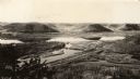
| Date: | 1930 |
|---|---|
| Description: | Elevated view of Perrot State Park (Trempealeau vicinity) looking west from Brady's Bluff toward the Mississippi River and Minnesota. Railroad tracks run a... |

| Date: | 1930 |
|---|---|
| Description: | Aerial view looking east at Mt. Trempealeau from Brady's Bluff in Perrot State Park. The Mississippi River is visible along the bluffs at upper left, and t... |

| Date: | |
|---|---|
| Description: | Three different signs with directions to Perrot State Park are lined up on a bench. |

| Date: | 1920 |
|---|---|
| Description: | This blue print map shows landownership between 1913 and 1916, topography, railroads, and roads. The map covers the vicinity of Perrot State Park. |
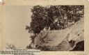
| Date: | 1888 |
|---|---|
| Description: | View looking up at three men and a child on top of a cliff on which are petroglyphs. Caption on photograph reads: "Pictograph Rock. Rock bearing aboriginal... |
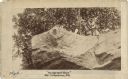
| Date: | 1888 |
|---|---|
| Description: | View looking up at three men and a child on top of a cliff on which are petroglyphs. Pictograph Rock bearing aboriginal carvings, located on the south side... |
| Date: | 1972 |
|---|---|
| Description: | Elevated view looking south towards the Mississippi River from Brady's Bluff in Perrot State Park. |
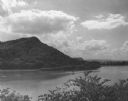
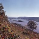
| Date: | 1952 |
|---|---|
| Description: | View of Perrot State Park from the opposite shore of the Mississippi river. |
If you didn't find the material you searched for, our Library Reference Staff can help.
Call our reference desk at 608-264-6535 or email us at: