 Filter: Categories of Wisconsin Historical Images
Filter: Community of Superior
Filter: Year of 1900-1999
Filter: Subject of transportation
Filter: Subject of superior, lake
Filter: Categories of Wisconsin Historical Images
Filter: Community of Superior
Filter: Year of 1900-1999
Filter: Subject of transportation
Filter: Subject of superior, lake
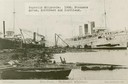
| Date: | 1900 |
|---|---|
| Description: | The Superior Shipyards showing steamers "Moran", "Northwest" and "Northland. Caption reads: "Ship Yards — McDougall Whaleback. West Superior, Wis." |

| Date: | 1915 |
|---|---|
| Description: | Bird's-eye view of Superior, Wisconsin, and Duluth, Minnesota on opposite shore of Lake Superior. |

| Date: | 1997 |
|---|---|
| Description: | The steel and reinforced concrete grain elevator built by the Great Northern Railroad at Superior about 1900. This contemporary photograph was taken to acc... |

| Date: | 1913 |
|---|---|
| Description: | Aerial bridge and harbor, with a large boat passing underneath. A lamppost and a beacon are along the walkway towards the bridge on the left. Caption reads... |

| Date: | 1900 |
|---|---|
| Description: | Elevated view of Tower Avenue. Caption reads: "Tower Avenue, Superior, Wis." |

| Date: | 1920 |
|---|---|
| Description: | Elevated view of the harbor. Caption reads: "The Harbor, Superior, Wis." |

| Date: | 1930 |
|---|---|
| Description: | Caption reads: "'The Old Standby' First Lighthouse Built at the Head of Lake Superior—Superior Entry — 1854 Keepers, Com. Saxton and Samuel Palmer." |

| Date: | 1915 |
|---|---|
| Description: | Elevated view of the harbor. Caption reads: "The Harbor, Superior, Wis." |

| Date: | 1910 |
|---|---|
| Description: | Caption reads: "The Great Northern. One of the largest Elevators in the World, Superior, Wis." |

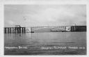
| Date: | 1961 |
|---|---|
| Description: | Aerial view of the Duluth-Superior bridge. |
| Date: | 1940 |
|---|---|
| Description: | View of the Arrowhead Bridge at the Duluth-Superior Harbor. |

| Date: | 1960 |
|---|---|
| Description: | Aerial view with docks in the foreground. Caption reads: "Superior, Wisconsin." |

| Date: | 1911 |
|---|---|
| Description: | This map, taken from the 1911 Map of Wisconsin showing geology and roads by Hotchkiss and Thwaites, shows the northwest portion of Douglas County, Wisconsi... |

| Date: | 1907 |
|---|---|
| Description: | This map of Superior and the vicinity shows selected company properties, railroads, and roads in a portion of Douglas County. The map reads: "Copyrighted 1... |

| Date: | 1909 |
|---|---|
| Description: | This map of Duluth and Superior was issued by the Duluth Street Railway Company and shows street railway routes in the cities, as well as lakes, bays, harb... |

| Date: | 1911 |
|---|---|
| Description: | This map of Duluth and Superior shows street car routes, railroads, ferries, some points of interest, and lighthouses. The bottom left of the map reads: "C... |

| Date: | 1934 |
|---|---|
| Description: | This map shows industrial points of interest in Superior. The top of the map reads: "Superior, Douglas County, Wisconsin, as this Industrial Tour map indic... |

| Date: | 1951 |
|---|---|
| Description: | This map of Superior shows labeled streets, waterways, railroads, and company ownership of docks. |

| Date: | 1932 |
|---|---|
| Description: | This map of Superior shows many points of interests including camping, fair grounds, docks, tourist attractions, lakes, roads, and waterways. |

| Date: | 1901 |
|---|---|
| Description: | This map shows streets, industrial buildings, a portion of Lake Superior and other lakes, bays, and rivers in portions of Duluth and Superior. Relief is sh... |
If you didn't find the material you searched for, our Library Reference Staff can help.
Call our reference desk at 608-264-6535 or email us at: