Filter: Categories of Wisconsin Historical Images
Filter: Community of Superior
Filter: Year of 1900-1999
Filter: Subject of cities and towns
Filter: Categories of Wisconsin Historical Images
Filter: Community of Superior
Filter: Year of 1900-1999
Filter: Subject of cities and towns
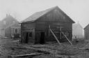
| Date: | 1930 |
|---|---|
| Description: | View of a barn, built between about 1875 and 1876. Buildings are in the background. |
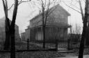
| Date: | 1900 |
|---|---|
| Description: | Exterior view of the Richard Bardon residence, with a man standing in front of it. |
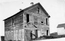
| Date: | 1930 |
|---|---|
| Description: | Exterior view of the Ashton home, built in about 1853 or 1854. |
| Date: | 1940 |
|---|---|
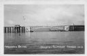
| Description: | View of the Arrowhead Bridge at the Duluth-Superior Harbor. |

| Date: | 1960 |
|---|---|
| Description: | Aerial view with docks in the foreground. Caption reads: "Superior, Wisconsin." |

| Date: | 1985 |
|---|---|
| Description: | Aerial view of the Duluth-Superior Bridge, officially named in honor of Richard I. Bong, World War II's Ace of Aces, who hailed from nearby Poplar, Wiscons... |
| Date: | 08 1947 |
|---|---|
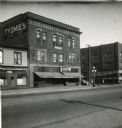
| Description: | Exterior view of the Tyomies Publishing Company building. The 6th Street Cafe is next door on the left. |
| Date: | 1919 |
|---|---|
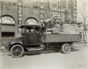
| Description: | A man sits in an International model "G" truck that has wood furniture and crates filling the bed. The building behind has signs advertising for a laundry. |
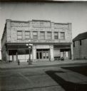
| Date: | 1900 |
|---|---|
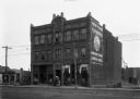
| Description: | The Russell Block, 1606-1608 Tower Avenue. The 1899 City Directory makes the first mention of New York Furriers, Simmons and Malik, proprietors. New York F... |

| Date: | 11 1952 |
|---|---|
| Description: | John Lavine (left), Nancy Jane Nelson, Virginia Rafshol, and Gary Berger indicate their support for the presidential candidacy of Dwight D. Eisenhower. As ... |

| Date: | 1911 |
|---|---|
| Description: | This map, taken from the 1911 Map of Wisconsin showing geology and roads by Hotchkiss and Thwaites, shows the northwest portion of Douglas County, Wisconsi... |

| Date: | 1907 |
|---|---|
| Description: | This map of Superior and the vicinity shows selected company properties, railroads, and roads in a portion of Douglas County. The map reads: "Copyrighted 1... |

| Date: | 1909 |
|---|---|
| Description: | This map of Duluth and Superior was issued by the Duluth Street Railway Company and shows street railway routes in the cities, as well as lakes, bays, harb... |

| Date: | 1909 |
|---|---|
| Description: | This map shows Duluth, Minnesota and Superior, Wisconsin, and portions of Saint Louis County, Minnesota and Douglas County, Wisconsin. Water depth is shown... |

| Date: | 1911 |
|---|---|
| Description: | This map of Duluth and Superior shows street car routes, railroads, ferries, some points of interest, and lighthouses. The bottom left of the map reads: "C... |

| Date: | 1925 |
|---|---|
| Description: | This map of Howard's Bay located at the Duluth Superior Harbor is a close view of Connors Point and shows a key to prevailing winds and water depth measure... |

| Date: | 1934 |
|---|---|
| Description: | This map shows industrial points of interest in Superior. The top of the map reads: "Superior, Douglas County, Wisconsin, as this Industrial Tour map indic... |

| Date: | 1916 |
|---|---|
| Description: | This map is mounted on cloth and shows lots and roads. An inset map is included that shows towns, lakes, rivers, and railroads within portions of the Dakot... |

| Date: | 1940 |
|---|---|
| Description: | This ward map shows streets, the Nemadji River, and addition and division boundaries. Also included is a list of members of the Douglas County Board town, ... |
If you didn't find the material you searched for, our Library Reference Staff can help.
Call our reference desk at 608-264-6535 or email us at: