 Filter: Categories of Wisconsin Historical Images
Filter: Community of Superior
Filter: Year of 1800-1899
Filter: Year of 1860-1869
Filter: Categories of Wisconsin Historical Images
Filter: Community of Superior
Filter: Year of 1800-1899
Filter: Year of 1860-1869

| Date: | 01 04 1862 |
|---|---|
| Description: | Engraving of the city of Superior and Lake Superior, also depicting railroad piers, Minnesota Point, and the steamboat "Star". The engraving appears on a l... |
| Date: | 08 28 1862 |
|---|---|
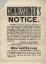
| Description: | A Commissioner's Notice of the draft, beginning on the first of September. On the first two days, claims of exemption from military service were to be hear... |
| Date: | 08 31 1862 |
|---|---|
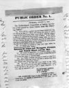
| Description: | Photograph of a printed broadside, Public Order No. 1., issued by The Committee of Safety. The first order appears to be addressing some kind of dangerous ... |

| Date: | 1860 |
|---|---|
| Description: | This map of Superior is oriented with north to the upper left. Relief is shown by hachures and water depths are shown by soundings. Lake Superior and bays ... |

| Date: | 1863 |
|---|---|
| Description: | This map of Superior shows Montgomery's Addition. An inset map shows the south west end of Lake Superior where Montgomery's Addition is located. The map re... |

| Date: | 1861 |
|---|---|
| Description: | This map shows lot and block numbers, piers, streets, monuments, and township section corners. Included is a note on the width of avenues, piers, slips, al... |
If you didn't find the material you searched for, our Library Reference Staff can help.
Call our reference desk at 608-264-6535 or email us at: