 Filter: Categories of Wisconsin Historical Images
Filter: Community of Superior
Filter: Year of 1800-1899
Filter: Categories of Wisconsin Historical Images
Filter: Community of Superior
Filter: Year of 1800-1899
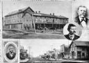
| Date: | 1885 |
|---|---|
| Description: | Collage of images featuring a view of the Nicollet House, a view down a main street, and portrait photographs of O.K. Hall, James Kane, and August Zachau. |
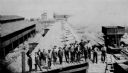
| Date: | 1890 |
|---|---|
| Description: | Elevated view of the coke ovens at the Lehigh Coal and Iron Company. A group of men are posing in the foreground. |
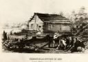
| Date: | 1855 |
|---|---|
| Description: | Chronicle newspaper office, the first building on the townsite of Superior, built in 1853 by William C. Howenstine, John T. Morgan, and August Zachau. |
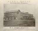
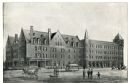
| Date: | 1880 |
|---|---|
| Description: | Exterior view of the Avery House, with groups of people gathered on its porches and balcony. |
| Date: | 1890 |
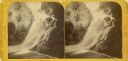
|---|---|
| Description: | Stereograph of Big Manitou Falls on the Black River. This waterfall reportedly was called "Gitchee Monido" by the Ojibwa, which means "Falls of the Great S... |

| Date: | 1890 |
|---|---|
| Description: | Big Manitou Falls on the Black River. This waterfall reportedly was called "Gitchee Monido" by the Ojibwa, which means "Falls of the Great Spirit." |
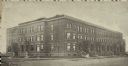
| Date: | 1891 |
|---|---|
| Description: | Exterior view of the West Superior Hotel. There are pedestrians, a street car, and people riding in horse-drawn carriages on the street in front of the hot... |
| Date: | 1890 |
|---|---|
| Description: | Exterior view from across street of Roosevelt Terrace apartments. |

| Date: | 1890 |
|---|---|
| Description: | Letterhead for Moulton, Moran & Co. The logo shows North America and depicts Superior as the center of a hub with spokes going to Russia, to China and Japa... |
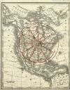
| Date: | 1890 |
|---|---|
| Description: | Rand, McNally map of North America enhanced to show Superior as the center of a wheel. The image was used on the back of stationery from City Improvement C... |
| Date: | 09 07 1895 |
|---|---|
| Description: | A garden of red currant bushes, owned by Jas. S. Ritchie, are featured on his fruit farm. |
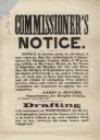
| Date: | 08 28 1862 |
|---|---|
| Description: | A Commissioner's Notice of the draft, beginning on the first of September. On the first two days, claims of exemption from military service were to be hear... |
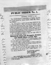
| Date: | 08 31 1862 |
|---|---|
| Description: | Photograph of a printed broadside, Public Order No. 1., issued by The Committee of Safety. The first order appears to be addressing some kind of dangerous ... |

| Date: | 1891 |
|---|---|
| Description: | Photograph of a painting by May Conniff Frost showing the tugboat Record of the Inman Line pulling a lake schooner through rough waters into Superio... |

| Date: | 1890 |
|---|---|
| Description: | This map of Superior shows labeled streets, railroads, docks, city wards, and the state line. Relief is shown by hachures. Below the title reads: "Bedford ... |

| Date: | 1890 |
|---|---|
| Description: | This map of Superior shows city wards, bays, docks, some businesses and points of interest. Relief is shown by hachures. The back of the map features a typ... |

| Date: | 1898 |
|---|---|
| Description: | This map of Superior shows city wards, bays, docks, and some businesses and points of interest. Relief is shown by hachures. The map probably came from a C... |

| Date: | 1898 |
|---|---|
| Description: | This map of Duluth and Superior show lands that "will be for sale soon" in portions of Douglas County, Wisconsin and Saint Louis County, Minnesota. The map... |

| Date: | 1860 |
|---|---|
| Description: | This map of Superior is oriented with north to the upper left. Relief is shown by hachures and water depths are shown by soundings. Lake Superior and bays ... |

| Date: | 1863 |
|---|---|
| Description: | This map of Superior shows Montgomery's Addition. An inset map shows the south west end of Lake Superior where Montgomery's Addition is located. The map re... |
If you didn't find the material you searched for, our Library Reference Staff can help.
Call our reference desk at 608-264-6535 or email us at: