 Filter: Categories of Wisconsin Historical Images
Filter: Community of Oshkosh
Filter: Categories of Wisconsin Historical Images
Filter: Community of Oshkosh

| Date: | 06 1890 |
|---|---|
| Description: | This map shows building use, railroads, tramways, lumber yards, roads, watchman’s stations, and steam pipes. Also included is text about buildings, Clapp a... |

| Date: | 1930 |
|---|---|
| Description: | This map shows city wards, streets, railroads, parks, Lake Butte Des Morts, Lake Winnebago, advertisements for Dixie Oils Gasoline, a list of Cook & Brown ... |

| Date: | 1850 |
|---|---|
| Description: | Waist-up pen and ink drawing of Chief Oshkosh. He is wearing a top hat wrapped with a ribbon. He wears a suitcoat, bowtie, beaded neckpouch and a blanket w... |

| Date: | 1858 |
|---|---|
| Description: | This map shows city wards, streets, block and lot numbers, cemeteries, buildings, landownership, forests, railroads, a race course, quarries, and orchards.... |

| Date: | 1877 |
|---|---|
| Description: | This map shows the Fox River, Lake Winnebago, city wards, lot and block numbers, landownership, selected buildings, railroads, and roads. There are three i... |
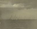
| Date: | 08 1916 |
|---|---|
| Description: | Class A sailboats race in the Inland Lake Yachting Association Regatta on Lake Winnebago just before a storm breaks. There are threatening clouds overhead. |
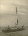
| Date: | 08 1916 |
|---|---|
| Description: | A description of this photograph written by Ernst Schmidt reads: "The 'Senta' with the anchor out shortly after the storm had hit. I am on the after deck —... |
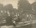
| Date: | 08 1916 |
|---|---|
| Description: | Bystanders watch as men bail out a sailboat and others assess the damage to their craft after a storm hit during the Inland Lake Yachting Association Regat... |

| Date: | 08 18 1931 |
|---|---|
| Description: | View across water towards sailboats with their crews reflected in the still waters of Lake Winnebago, before the start of a race at the Inland Lake Yachtin... |

| Date: | 1908 |
|---|---|
| Description: | This blueprint map is showing subdivisions and additions. Streets, rivers, and land plots are labeled. |

| Date: | 1855 |
|---|---|
| Description: | This map shows the Fox River, Lake Winnebago, streets, and plats. Below the title reads: "N. F.&Co. will make surveys of lands and plat the same in the bes... |

| Date: | 1900 |
|---|---|
| Description: | Map showing a paper city located on the shore of Green Bay and south shore of the Fox River. The site is now part of Oshkosh. |

| Date: | 1900 |
|---|---|
| Description: | Map showing city wards, streets, block and lot numbers, additions, selected buildings, Lake Winnebago, the Fox River, and railroads as of 1895. The lower m... |

| Date: | 1926 |
|---|---|
| Description: | This blueprint map is oriented with north to the upper left. The map shows buildings with note of those "to be torn down," sidewalks, proposed power plant,... |
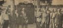
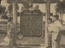
| Date: | 06 05 1955 |
|---|---|
| Description: | Officials gathered to dedicate the Knaggs Ferry historical marker in Oshkosh. The officials included, from left to right, Edward Hamilton, vice-president o... |
| Date: | 06 05 1955 |
|---|---|
| Description: | Fourth, fifth, and sixth generations of the Knaggs family gathered by the Knaggs Ferry historical marker to honor their family member. Mrs. Walter Dugolens... |

| Date: | 1860 |
|---|---|
| Description: | A photographic copy of an early, full-length studio portrait of Elizabeth Farnsworth Mears (1830-1907) standing in front of a painted backdrop with column ... |

| Date: | |
|---|---|
| Description: | Waist-up carte-de-visite studio portrait of John Hall Mears. |

| Date: | 1910 |
|---|---|
| Description: | View from street of a two-story wood frame house, with open front porch shaded by trees. There is a plank sidewalk in front and a curved plank walk leading... |
If you didn't find the material you searched for, our Library Reference Staff can help.
Call our reference desk at 608-264-6535 or email us at:
