Filter: Categories of Wisconsin Historical Images
Filter: Community of Mineral Point
Filter: Year of 1900-1999
Filter: Year of 1900-1909
Filter: Categories of Wisconsin Historical Images
Filter: Community of Mineral Point
Filter: Year of 1900-1999
Filter: Year of 1900-1909
| Date: | 1900 |
|---|---|
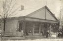
| Description: | The First National Bank that was the Iowa County Building between 1843 and 1860, then the W.T. Henry Bank and post office. Men are standing outside on the ... |
| Date: | 1905 |
|---|---|
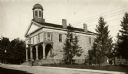
| Description: | The second Iowa County Court House, built in 1842 and used as such until 1861. The building was torn down in 1913. |

| Date: | 1905 |
|---|---|
| Description: | Slightly elevated view across street towards the second Iowa County Court House, built in 1842. For a time in 1846, the space was leased to the newly organ... |

| Date: | 1900 |
|---|---|
| Description: | A primitive Methodist Church building. Caption reads: "Old P.M. Church Mineral Point, Wis." |

| Date: | 1900 |
|---|---|
| Description: | The home of Moses Strong, a prominent attorney, politician, speculator and land agent who moved to Wisconsin Territory and settled in Mineral Point in 1836... |
| Date: | 1900 |
|---|---|
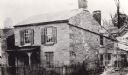
| Description: | A Cornish miner's cottage on Shake Rag Street called Trelawny. The cottage was restored under the ownership of Robert M. Neal and is now used to serve Corn... |

| Date: | 1905 |
|---|---|
| Description: | Looking up toward Castle Rock in Mineral Point. A group of people are standing at the top. Caption reads: "Castle Rock, Mineral Point, Wis." |

| Date: | 1905 |
|---|---|
| Description: | A watertower in Mineral Point. Caption reads: "Watertower, Mineral Point, Wis." |
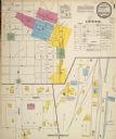
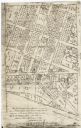
| Date: | 1900 |
|---|---|
| Description: | Sanborn map of Mineral Point, sheet 1. |
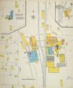
| Date: | 1900 |
|---|---|
| Description: | Sanborn map, sheet 5, of a portion of Mineral Point. |
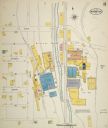
| Date: | 08 1908 |
|---|---|
| Description: | Sanborn map of a portion of Mineral Point. |
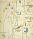
| Date: | 1908 |
|---|---|
| Description: | Sanborn map, sheet 7, of a portion of Mineral Point. |

| Date: | 02 12 1900 |
|---|---|
| Description: | Front Row: Edyth Jobe, Joe Nunamaker, Tommy Bradshaw, Bob Winnett, Jack Williams, Alex Nunamaker, Lee Winnett, and Ethel Baumgartner. Second Row: Cora Jobe... |

| Date: | 1900 |
|---|---|
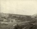
| Description: | View looking down hill of open, grassy fields and houses on a hill in the distance. At the bottom of the hill in the foreground is a stream running through... |
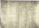
| Date: | 1900 |
|---|---|
| Description: | This facsimile of manuscript map shows lot numbers, dimensions, streets, and township lines. The bottom left corner includes a certification. |
| Date: | 1900 |
|---|---|
| Description: | This facsimile of a manuscript map shows lots and streets. The lower left corner includes a certification. |
If you didn't find the material you searched for, our Library Reference Staff can help.
Call our reference desk at 608-264-6535 or email us at: