 Filter: Categories of Wisconsin Historical Images
Filter: Community of La Crosse
Filter: Year of 1800-1899
Filter: Subject of rivers
Filter: Categories of Wisconsin Historical Images
Filter: Community of La Crosse
Filter: Year of 1800-1899
Filter: Subject of rivers
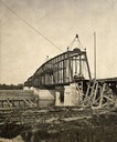
| Date: | 1880 |
|---|---|
| Description: | Construction of a railroad bridge on the Chicago, Milwaukee, and St. Paul Railroad line. A set of railroad tracks is in the foreground, running along the s... |
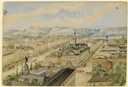
| Date: | 04 1860 |
|---|---|
| Description: | Accompanying this sketch is Hölzlhuber's description of his last foray from Milwaukee before leaving America. "Before my return to Europe, D. Brandis, the ... |

| Date: | 1873 |
|---|---|
| Description: | A map that covers parts of Winona and Houston Counties, Minnesota and La Crosse County, Wisconsin, showing the proposed railroad routes, constructed rail l... |

| Date: | 1856 |
|---|---|
| Description: | This map of the City of La Crosse is a plat of Pike & Co's Addition. The map shows street names, block and lot numbers, the South La Crosse River, and the ... |

| Date: | 1874 |
|---|---|
| Description: | This map of La Crosse is accompanied by other plats of subdivision of the city. The relief is shown by hachures. The additions include: Rudolf Gripps Addit... |

| Date: | 1859 |
|---|---|
| Description: | This map show plats including plat names, plat numbers, and some lot owner's names. Relief is shown by hachures. The map includes line drawings of Juneau B... |

| Date: | 1872 |
|---|---|
| Description: | This map is pencil, ink, and watercolor on paper. Shown on the map is the elevation and profile of La Crescent Bottoms, Mt. Vernon Street line, 13th Street... |

| Date: | 1874 |
|---|---|
| Description: | This map has relief shown by hachures and includes 7 inset maps of additions and subdivisions with varying scales. Also includes index of additions and loc... |

| Date: | 1857 |
|---|---|
| Description: | This map shows section corners, quarter section corners, foundry, steam saw mill, steam grist mill, planning mill, court house, baptist church, congregatio... |

| Date: | 1883 |
|---|---|
| Description: | This map shows ward boundaries, names of additions, streets, bridges, mills, schools, religious buildings, businesses, hotels, railroads, factories, brewer... |

| Date: | 1876 |
|---|---|
| Description: | This map is ink on tracing cloth and shows the Black River, French Slough, Little French Slough, the southern portion of North La Crosse, the Milwaukee & S... |

| Date: | 1891 |
|---|---|
| Description: | This hand-colored map shows platted additions and subdivisions, ward boundaries, schools, churches, railroads, cemeteries, parks, businesses, factories, an... |
If you didn't find the material you searched for, our Library Reference Staff can help.
Call our reference desk at 608-264-6535 or email us at: