 Filter: Categories of Wisconsin Historical Images
Filter: Community of Janesville
Filter: Year of 1800-1899
Filter: Categories of Wisconsin Historical Images
Filter: Community of Janesville
Filter: Year of 1800-1899

| Date: | 1853 |
|---|---|
| Description: | Map covers area between the cities of Janesville and Kenosha in Rock, Walworth, and Kenosha counties for railroad routes. Lakes and counties are labelled. ... |

| Date: | 1860 |
|---|---|
| Description: | Map showing a plat of the city, land ownership by name, wards by number, local streets, buildings, fair grounds, nurseries, and part of Rock River. The map... |
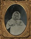
| Date: | 1862 |
|---|---|
| Description: | Ninth plate ferrotype/tintype of William Cowper Noyes as an infant. Son of William B. Noyes and Julia (Page) Noyes of Janesville. William died at the age o... |

| Date: | 1873 |
|---|---|
| Description: | This map shows landownership and acreages, lot and block numbers, roads and railroads, marshes, schools, churches, mills, rural buildings, and quarries. Re... |

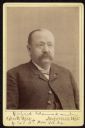
| Date: | 08 1896 |
|---|---|
| Description: | Quarter-length portrait of a man wearing a suit and tie, with three medals pinned to his chest. This is Dr. Joseph Bellamy Whiting, who was a physician in ... |
| Date: | 1887 |
|---|---|
| Description: | Waist-up carte-de-visite portrait of Richard Adams, a member of the 16th Wisconsin Volunteer Infantry, Company "F." |
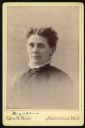
| Date: | 1887 |
|---|---|
| Description: | Vignetted carte-de-visite portrait of a woman identified as "Mrs. Adams." |
If you didn't find the material you searched for, our Library Reference Staff can help.
Call our reference desk at 608-264-6535 or email us at: