 Filter: Categories of Wisconsin Historical Images
Filter: Community of Beloit
Filter: Year of 1800-1899
Filter: Subject of cities and towns
Filter: Categories of Wisconsin Historical Images
Filter: Community of Beloit
Filter: Year of 1800-1899
Filter: Subject of cities and towns

| Date: | 1890 |
|---|---|
| Description: | Bird's-eye map of Beloit with insets of Williams Engine Works, Eclipse Wind Engine Co., and John Foster & Co. Turtle Creek is in the lower section, and the... |

| Date: | 1874 |
|---|---|
| Description: | Bird's-eye view of Beloit, with insets of Beloit College, Beloit High School, and Memorial Hall. |
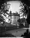
| Date: | 1875 |
|---|---|
| Description: | View across wooden platform of a brick high school on a hill surrounded by a fence. The school has a mansard roof and what appears to be a bell tower above... |
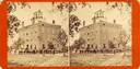
| Date: | 1885 |
|---|---|
| Description: | Stereograph view of the Middle College building. Groups of men are posing standing in front, and other men are posing at the entrance and in open windows. ... |
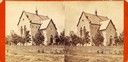
| Date: | 1885 |
|---|---|
| Description: | Stereograph view of Beloit College Chapel, with the congregation posed outside on the lawn. |
| Date: | 1885 |
|---|---|
| Description: | Stereograph view of Memorial Hall at Beloit College. |
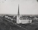
| Date: | 1877 |
|---|---|
| Description: | Elevated view of the First Congregational Church. Behind the church are buildings in the downtown area. |
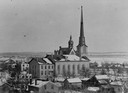
| Date: | 1877 |
|---|---|
| Description: | Elevated view over houses towards the First Congregational Church in winter. |
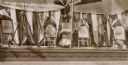
| Date: | 1895 |
|---|---|
| Description: | Window display in Bort, Bailey & Co. store on the occasion of a Civil War Veterans' reunion. In the window is a display of images of President Lincoln, Gen... |

| Date: | 1885 |
|---|---|
| Description: | Stereograph view of Memorial Hall at Beloit College. |

| Date: | 1800 |
|---|---|
| Description: | This map on two sheets shows a group of ancient mounds near the southeast corner of the city of Beloit and a group of ancient mounds north of Rockton Stati... |
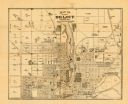
| Date: | 1887 |
|---|---|
| Description: | This map of Beloit shows labeled wards, plat of town, roads, railroads, the Rock River, city boundaries, and land ownership by name. The back of the map is... |

| Date: | 1850 |
|---|---|
| Description: | This map shows a plat of the town, land owners by name, local streets, railroads, churches, and part of the Rock River. The map is also indexed by church d... |

| Date: | 1873 |
|---|---|
| Description: | This map shows land ownership by name, local streets, railroads, parks, college grounds, schools, cemeteries, and part of Rock River. The upper left margin... |
If you didn't find the material you searched for, our Library Reference Staff can help.
Call our reference desk at 608-264-6535 or email us at: