Filter: Categories of Wisconsin Historical Images
Filter: Community of Ashland
Filter: Year of 1800-1899
Filter: Categories of Wisconsin Historical Images
Filter: Community of Ashland
Filter: Year of 1800-1899
| Date: | 1890 |
|---|---|
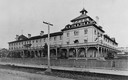
| Description: | View of the original Hotel Chequamegon, built by the Wisconsin Central Railroad interests and opened in 1877. It was built of wood with a wrap around porch... |

| Date: | 1885 |
|---|---|
| Description: | View of the ore dock of the Milwaukee, Lake Shore, and Western Railroad. Large logs, buildings and a railroad bridge are in the foreground. |
| Date: | 1890 |
|---|---|
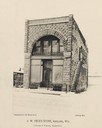
| Description: | Front view of G.W. Peck's Store. The ground is covered with snow. The signs on the building read "Globe Steam Laundry" and the text below the photograph re... |
| Date: | 1890 |
|---|---|
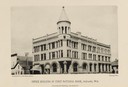
| Description: | View of the Vaughn Library building, built of brick in 1888 in the Romanesque Revival style. It was supported by retail, apartments and offices located on ... |
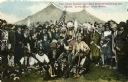
| Date: | 1896 |
|---|---|
| Description: | Colored postcard view of "Buffalo Bill" Cody center right in white coat and hat surrounded by Native Americans in traditional garb, military personnel and ... |

| Date: | 1887 |
|---|---|
| Description: | This 1887 map of Ashland County, Wisconsin, shows the township and range system, sections, railroads, vacant Wisconsin Central Railroad land, state and "go... |

| Date: | 1896 |
|---|---|
| Description: | This 1896 map shows the township and range system, sections, cities and villages, railroads, roads, vacant land and land sold by the Wisconsin Central Rail... |

| Date: | 1896 |
|---|---|
| Description: | This 1898 map shows the township and range system, sections, cities and villages, railroads, roads, vacant land and land sold by the Wisconsin Central Rail... |

| Date: | 1800 |
|---|---|
| Description: | The map is ink and pencil on paper. Map shows the location of the Ashland Lumber Company as well as a portion of Ashland County. Portions of the map are in... |

| Date: | 1850 |
|---|---|
| Description: | Map is pen and pencil on paper. The map shows roads, creeks, and the Chequamegon Bay. The map is undated and prepared sometime between the establishment of... |

| Date: | 09 04 1885 |
|---|---|
| Description: | Exterior and interior bill of fare from The Chequamegon, with views on the back of rock formations, waterfalls, a spot illustration of a train going over a... |

| Date: | 1888 |
|---|---|
| Description: | This map shows wards and includes the Chequamegon Bay and Washburn. An inset map shows the Ashland region, its railroads, and a few of its iron mines. |

| Date: | 1895 |
|---|---|
| Description: | Stereograph of the side cliff view of the railroad White River bridge, showing the support beams and river underneath. It is six miles south of Ashland. Th... |
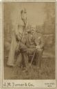
| Date: | 06 19 1890 |
|---|---|
| Description: | Studio portrait in front of a painted backdrop of a woman and man posing together. The man is sitting in a chair holding a hat and an umbrella. The woman i... |
If you didn't find the material you searched for, our Library Reference Staff can help.
Call our reference desk at 608-264-6535 or email us at: