Filter: Categories of Wisconsin Historical Images
Filter: Creator Name of Wisconsin. Conservation Department.
Filter: Categories of Wisconsin Historical Images
Filter: Creator Name of Wisconsin. Conservation Department.
| Date: | 1938 |
|---|---|
| Description: | The 45th parallel of north latitude marker, marking halfway between the equator and the north pole. The marker is located on Highway 141, three miles north... |
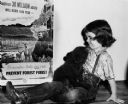
| Date: | 1950 |
|---|---|
| Description: | Smokey Bear cub with Judy Bell in front of a fire-prevention poster featuring the character for whom the young bear was named. |

| Date: | 1950 |
|---|---|
| Description: | Smokey Bear cub receives treatment from Dr. Edwin J. Smith of Santa Fe, for burns he suffered in a forest fire. |
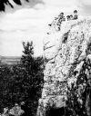
| Date: | 1936 |
|---|---|
| Description: | A rock outcropping with children at Rib Mountain State Park. |

| Date: | 1930 |
|---|---|
| Description: | A view looking west at Rib Mountain across the Wisconsin River from the outskirts of Wausau. |
| Date: | 1950 |
|---|---|
| Description: | A view from Rib Mountain looking southeast toward Rothschild and the Wisconsin River. The sign on the road in the foreground reads: "Dangerous Road, Drive ... |
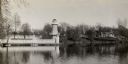
| Date: | 1930 |
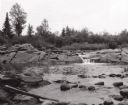
|---|---|
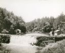
| Description: | View of the mill dam on Dell Creek that creates Mirror Lake in Mirror Lake State Park (although the photograph was taken before the site was designated as ... |
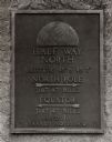
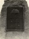
| Date: | |
|---|---|
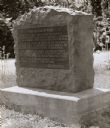
| Description: | Old Lead Road Marker. Marker reads: "The Old Lead Road. In 1828, ox-teams, guided along an ancient Winnebago Indian Trail, began hauling over this road. Ju... |
| Date: | 1945 |
|---|---|
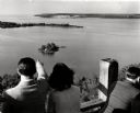
| Description: | People on observation tower looking at Sturgeon Bay. |
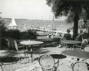
| Date: | 1952 |
|---|---|
| Description: | University of Wisconsin-Madison Memorial Union Terrace with Lake Mendota and sailboats in the background. |
| Date: | 1940 |
|---|---|
| Description: | A view of a marker on highway 41 designating the half way point between the Equator and the North Pole. |
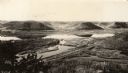
| Date: | 1930 |
|---|---|
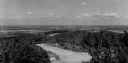
| Description: | Elevated view of Perrot State Park (Trempealeau vicinity) looking west from Brady's Bluff toward the Mississippi River and Minnesota. Railroad tracks run a... |

| Date: | 1930 |
|---|---|
| Description: | Aerial view looking east at Mt. Trempealeau from Brady's Bluff in Perrot State Park. The Mississippi River is visible along the bluffs at upper left, and t... |
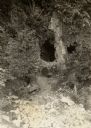
| Date: | 1940 |
|---|---|
| Description: | A view of some caves at Peninsula State Park. |
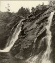
| Date: | 1938 |
|---|---|
| Description: | Little Manitou Falls on the Black River. Referred to as the "upper falls" in the park. A person is sitting on the rocks on top of the falls. This waterfall... |
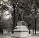
| Date: | 1936 |
|---|---|
| Description: | Chief Oshkosh's statue and grave. Located in Menominee Park, formerly North Park. |
| Date: | 1935 |
|---|---|
| Description: | Lake Okauchee lighthouse. Buildings are in the background along a tree-covered shoreline. |

| Date: | |
|---|---|
| Description: | A man in a plaid jacket is feeding a bottle of milk to a fawn. |
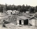
| Date: | 1950 |
|---|---|
| Description: | Elevated view of land operations of commercial fishing operation with fish net drying reels and buildings on Apostle Islands. |
If you didn't find the material you searched for, our Library Reference Staff can help.
Call our reference desk at 608-264-6535 or email us at: