 Filter: Categories of Wisconsin Historical Images
Filter: Creator Name of Wisconsin. Conservation Department.
Filter: Subject of work
Filter: Categories of Wisconsin Historical Images
Filter: Creator Name of Wisconsin. Conservation Department.
Filter: Subject of work

| Date: | 1936 |
|---|---|
| Description: | This 1936 Wisconsin Conservation Dept. map shows the locations of state forestry Civilian Conservation Corps (CCC) camps, closed state forestry CCC camps, ... |

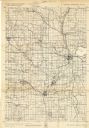
| Date: | 1937 |
|---|---|
| Description: | This Wisconsin Conservation Department map shows the locations of state forests, national forests, county forests, state nurseries, Indian reservations, st... |
| Date: | 1940 |
|---|---|
| Description: | This quadrangle collection of maps, meaning geological surveys, shows sections of central and northern Wisconsin. The maps include a quadrangle index map. ... |
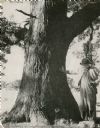
| Date: | 1952 |
|---|---|
| Description: | An unidentified man, probably H.M. Phelps, posing with his right hand resting on the massive trunk of a bur oak which grew on the Phelps farm three miles w... |

| Date: | 1935 |
|---|---|
| Description: | A man with a hammer is working at the top of a telephone pole as a second man is watching from the ground. There is a third man near a man on another pole ... |
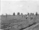
| Date: | 1935 |
|---|---|
| Description: | A large crew of men are bending to their work of planting seedling trees into furrows. Each man is carrying a spade-like tool with a long handle, and a box... |
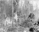
| Date: | 1936 |
|---|---|
| Description: | Three men, members of the Civilian Conservation Corps, fighting a forest fire. Two of the men have shovels; the third is directing a stream of water from a... |

| Date: | 1950 |
|---|---|
| Description: | A young man wearing jeans and a t-shirt is handling the luggage as two well-dressed women exit a small seaplane. The pilot is watching from inside the plan... |
If you didn't find the material you searched for, our Library Reference Staff can help.
Call our reference desk at 608-264-6535 or email us at: