 Filter: Categories of Wisconsin Historical Images
Filter: Creator Name of Wisconsin. Conservation Department.
Filter: Subject of roads
Filter: Categories of Wisconsin Historical Images
Filter: Creator Name of Wisconsin. Conservation Department.
Filter: Subject of roads
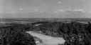
| Date: | 1950 |
|---|---|
| Description: | A view from Rib Mountain looking southeast toward Rothschild and the Wisconsin River. The sign on the road in the foreground reads: "Dangerous Road, Drive ... |

| Date: | 1958 |
|---|---|
| Description: | Includes images of Flambeau River State Forest and a description of, canoeing and recreational activities in, and general park and forest information about... |

| Date: | 1952 |
|---|---|
| Description: | This Wisconsin Conservation Dept. map shows sections, roads, rivers, and lakes in the Town of Cloverland, Vilas County, Wisconsin as of February, 1952. It ... |

| Date: | 1952 |
|---|---|
| Description: | This Wisconsin Conservation Dept. map shows sections, roads, rivers, and lakes in the Town of Presque Isle, Vilas County, Wisconsin as of March 1953. It do... |

| Date: | |
|---|---|
| Description: | View down dirt road through cut-over and burned-over terrain. |

| Date: | 1935 |
|---|---|
| Description: | Two logging roads diverge in a stand of burned jack pine trees, dividing the scene into three parts. In the background, near the left branch of the road, t... |

| Date: | 1940 |
|---|---|
| Description: | A log gate and log-framed sign mark the entrance to the Twin River (Rawley) Point lighthouse. The keeper's house is next to the light and has a turret and ... |

| Date: | 1950 |
|---|---|
| Description: | Sunshine brightens autumn oak and maple leaves along a narrow road identified as Razorback Trail. There are also birch and evergreen trees in the woods. |

| Date: | 11 23 1949 |
|---|---|
| Description: | Elevated view of a field, with farmland, roads, houses, and groves of trees. |
If you didn't find the material you searched for, our Library Reference Staff can help.
Call our reference desk at 608-264-6535 or email us at: