 Filter: Categories of Wisconsin Historical Images
Filter: Creator Name of Wisconsin. Conservation Department.
Filter: Subject of outdoor photography
Filter: Categories of Wisconsin Historical Images
Filter: Creator Name of Wisconsin. Conservation Department.
Filter: Subject of outdoor photography
| Date: | 1965 |
|---|---|
| Description: | The sand dunes in Kohler-Andrae State Park, named after John Michael Kohler and Terry Andrae. |
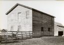
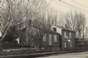
| Date: | 1940 |
|---|---|
| Description: | Building used as a lodging house for the First Territorial Legislature held in Belmont in 1836. |

| Date: | 1940 |
|---|---|
| Description: | Building used as a lodging house for the First Territorial Legislature held in Belmont in 1836. |
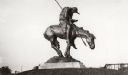
| Date: | |
|---|---|
| Description: | View of the bronze sculpture entitled: "The End of the Trail." |
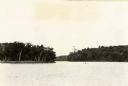
| Date: | 1940 |
|---|---|
| Description: | View of Taylor Lake and the entrance to Chain O' Lakes. |
| Date: | |
|---|---|
| Description: | The Pendarvis house, a Cornish home on Shake Rag Street. |
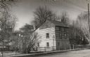
| Date: | 1945 |
|---|---|
| Description: | A restored Cornish miner's house, called Polperro, on Shake Rag Street. The house was temporarily covered with siding, but after restoration the siding was... |
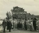
| Date: | |
|---|---|
| Description: | Group of resort and hotel owners gathered in front of a Wisconsin tourism sign that reads: "Relax In Wisconsin." There is a building in the background. |
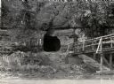
| Date: | 1950 |
|---|---|
| Description: | View across river towards the tunnel leading to the bottom of the shot tower shaft at Tower Hill State Park. There is a rustic bridge on the right leading ... |

| Date: | 1953 |
|---|---|
| Description: | View across water towards the Sturgeon Bay Canal Lighthouse, with a group of people in a motorboat in the foreground. |
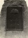
| Date: | 1938 |
|---|---|
| Description: | The 45th parallel of north latitude marker, marking halfway between the equator and the north pole. The marker is located on Highway 141, three miles north... |
| Date: | 1936 |
|---|---|
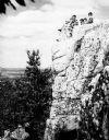
| Description: | A rock outcropping with children at Rib Mountain State Park. |

| Date: | 1930 |
|---|---|
| Description: | A view looking west at Rib Mountain across the Wisconsin River from the outskirts of Wausau. |
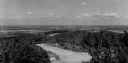
| Date: | 1950 |
|---|---|
| Description: | A view from Rib Mountain looking southeast toward Rothschild and the Wisconsin River. The sign on the road in the foreground reads: "Dangerous Road, Drive ... |
| Date: | 1930 |
|---|---|
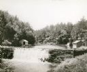
| Description: | View of the mill dam on Dell Creek that creates Mirror Lake in Mirror Lake State Park (although the photograph was taken before the site was designated as ... |
| Date: | |
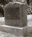
|---|---|
| Description: | Old Lead Road Marker. Marker reads: "The Old Lead Road. In 1828, ox-teams, guided along an ancient Winnebago Indian Trail, began hauling over this road. Ju... |
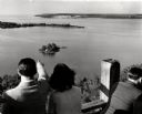
| Date: | 1945 |
|---|---|
| Description: | People on observation tower looking at Sturgeon Bay. |
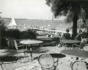
| Date: | 1952 |
|---|---|
| Description: | University of Wisconsin-Madison Memorial Union Terrace with Lake Mendota and sailboats in the background. |
| Date: | 1940 |
|---|---|
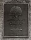
| Description: | A view of a marker on highway 41 designating the half way point between the Equator and the North Pole. |
| Date: | 1930 |
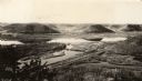
|---|---|
| Description: | Elevated view of Perrot State Park (Trempealeau vicinity) looking west from Brady's Bluff toward the Mississippi River and Minnesota. Railroad tracks run a... |
If you didn't find the material you searched for, our Library Reference Staff can help.
Call our reference desk at 608-264-6535 or email us at: