 Filter: Categories of Wisconsin Historical Images
Filter: Creator Name of Wisconsin State Journal
Filter: Subject of roads
Filter: Categories of Wisconsin Historical Images
Filter: Creator Name of Wisconsin State Journal
Filter: Subject of roads
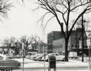
| Date: | 1955 |
|---|---|
| Description: | West Doty Street, from Monona Avenue looking toward South Carroll Street, showing the back side of Madison Newspapers, Inc. The building was added on to in... |

| Date: | 1914 |
|---|---|
| Description: | Shows land ownership by name, rural routes, improved roads, railroads, schools, churches, and cemeteries. "For list of small property owners, lift map at f... |

| Date: | 1927 |
|---|---|
| Description: | This map shows roads, highways, cities, county boundaries, rivers, lakes and trails. The route from Chicago to Duluth (including Wisconsin Highways 13 and ... |
If you didn't find the material you searched for, our Library Reference Staff can help.
Call our reference desk at 608-264-6535 or email us at: