Filter: Categories of Wisconsin Historical Images
Filter: Creator Name of Vanderbilt, Paul
Filter: Subject of roads
Filter: Categories of Wisconsin Historical Images
Filter: Creator Name of Vanderbilt, Paul
Filter: Subject of roads
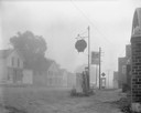
| Date: | 08 20 1961 |
|---|---|
| Description: | Street scene with a Shell gasoline station, the Kitty Korner Kafe, and a phone booth in early morning fog. |
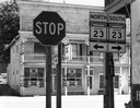
| Date: | 07 05 1965 |
|---|---|
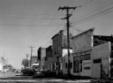
| Description: | Street corner with gasoline station, 7-Up sign in front of restaurant next door, and several storefronts across the street. |
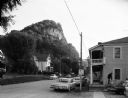
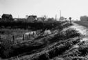
| Date: | 09 06 1964 |
|---|---|
| Description: | Mississippi River fishing town, bluff in background, looking south from a main street and showing arcade passage through store fronts. |

| Date: | 05 31 1965 |
|---|---|
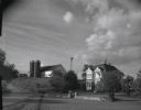
| Description: | Elevated view of Evangelical United Brethren church in the vicinity of Highway T. |
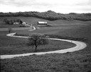
| Date: | 05 12 1963 |
|---|---|
| Description: | Winding farm road and distant farm with tree-covered hill in the background. |

| Date: | 12 01 1962 |
|---|---|
| Description: | A farm road between fields in late sunlight, looking towards Mounds Creek in the vicinity of CTH F. |
| Date: | 10 03 1960 |
|---|---|
| Description: | Early morning at a railroad crossing on County Highway A, with houses and a barn in the distance. |
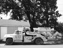
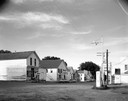
| Date: | 07 24 1960 |
|---|---|
| Description: | A mobile silage processing equipment truck owned by the Black Earth Farm Service company. |
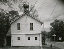
| Date: | 1963 |
|---|---|
| Description: | View towards the Fire Station, with garage doors and a bell tower on the roof. A road is on the right. |
| Date: | 09 18 1961 |
|---|---|
| Description: | Main street of the town, shown during reconstruction for use as a motion picture set. |
| Date: | 1958 |
|---|---|
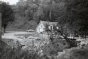
| Description: | Nelson Dewey State Park (Cassville vicinity). Bridge construction near the park office which was built in the 1850s as a chicken house. The park was establ... |
| Date: | 1963 |
|---|---|
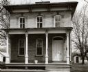
| Description: | A house with a porch. An example of mid-nineteenth century architecture at 632 East Main Street. |
| Date: | 1964 |
|---|---|
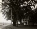
| Description: | A view to the horizon looking down Mineral Point Road, with a country house on the right under trees, during early evening hours. |
| Date: | 08 05 1962 |
|---|---|
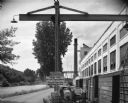
| Description: | Exterior view of Riverside Paper Corporation mill. On the left is a road along a river, and on the right are railroad tracks along the mill. A sign in the ... |
| Date: | 10 03 1960 |
|---|---|
| Description: | View from field of the W. Blise farm. A barn with two silos, a windmill and a large house are visible. A stone wall landscapes the area in front of the hou... |
| Date: | 10 23 1960 |
|---|---|
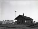
| Description: | View of the Barneveld railroad station with several business, including the "Theobald Cafe" and the "Village Bar" behind the station along a street. |

| Date: | 09 19 1961 |
|---|---|
| Description: | View from road of All Saint's Church behind a group of trees. The front entrance is on the right, with a signboard nearby listing times of the masses and c... |

| Date: | 07 31 1960 |
|---|---|
| Description: | View of a tree and mailbox, with a farmhouse behind below road level along a rural highway. There is a hill in the background with trees. |

| Date: | 07 1962 |
|---|---|
| Description: | View from the Wisconsin State Capitol looking west down State Street. A man and woman walk up the stairs leading to the capitol building. |
If you didn't find the material you searched for, our Library Reference Staff can help.
Call our reference desk at 608-264-6535 or email us at: