 Filter: Categories of Wisconsin Historical Images
Filter: Creator Name of Unknown
Filter: Community of Blooming Grove
Filter: Categories of Wisconsin Historical Images
Filter: Creator Name of Unknown
Filter: Community of Blooming Grove
| Date: | |
|---|---|
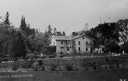
| Description: | Oakleigh Lodge on the south shore of Lake Monona, one-time home of Dr. and Mrs. William Reginald Reynolds of Dublin, Ireland, who purchased the house and 6... |

| Date: | 1911 |
|---|---|
| Description: | Plat Map of Blooming Grove in "Atlas of Dane County, Wisconsin." |

| Date: | 1887 |
|---|---|
| Description: | View across water towards the Tonyawatha Spring Hotel on Lake Monona. The hotel, on the east shore of the lake, is located in Blooming Grove Township, just... |
| Date: | 1885 |
|---|---|
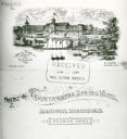
| Description: | From the cover of a descriptive brochure in the Historical Society's Library pamphlet collection, this drawing depicts the large hotel grounds on Lake Mono... |
| Date: | 1895 |
|---|---|
| Description: | View of the Tonyawatha Spring Hotel grounds, located on Lake Monona in Blooming Grove Township, just outside of Madison. The hotel opened in 1879 and on Ju... |

| Date: | 08 1927 |
|---|---|
| Description: | Outdoor portrait of former boxer, Tommy Gibbons, Father Gordon, and Governor Fred R. Zimmerman at a Ho Chunk (Winnebago) ceremony. Zimmerman is wearing a b... |

| Date: | 1927 |
|---|---|
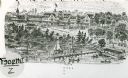
| Description: | Blueprint-style map of Frost Woods on the shore of Lake Monona. The map indicates the locations of Indian mounds, an Indian camp, and various plants. There... |
| Date: | 07 05 1928 |
|---|---|
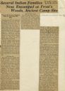
| Description: | Article entitled "Several Indian Families Now Encamped at Frost's Woods, Ancient Camp Site" about Winnebago (Ho-Chunk) Indians camping on the shores of Lak... |
| Date: | 07 28 1926 |
|---|---|
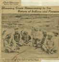
| Description: | Newspaper clipping including headline, photograph of six Winnebago (Ho Chunk) Indians, and a caption indicating that the men pictured would be attending a ... |
| Date: | 1993 |
|---|---|
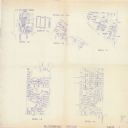
| Description: | This collection of maps includes two pages of seven detailed plats of different sub divisions and areas of the township. |

| Date: | |
|---|---|
| Description: | Farm workers spreading hay onto two haystacks on farm on the east side of Highway 51 north of Pflaum Road. Three teams of horses, wearing fly-nets, are pro... |
If you didn't find the material you searched for, our Library Reference Staff can help.
Call our reference desk at 608-264-6535 or email us at: