Filter: Categories of Wisconsin Historical Images
Filter: Creator Name of Newhouse, John
Filter: Subject of fields (agriculture)
Filter: Categories of Wisconsin Historical Images
Filter: Creator Name of Newhouse, John
Filter: Subject of fields (agriculture)

| Date: | 1956 |
|---|---|
| Description: | Aerial view of the South Park Street interchange. |

| Date: | 1950 |
|---|---|
| Description: | Aerial view of the Frank Lloyd-Wright-dsigned Unitarian Church under construction and the Veteran's Administration Hospital, also under construction, to th... |
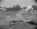
| Date: | |
|---|---|
| Description: | Myrland's Sky Lodge, a vacation resort near Montello that boasted a private landing strip for pilots with small planes. The Piper Vagabond in the foregroun... |
| Date: | |
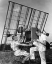
|---|---|
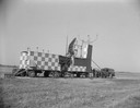
| Description: | Radar equipment at Truax Field, formerly Madison Municipal Airport. |

| Date: | 1956 |
|---|---|
| Description: | Aerial view of the new Madison television facility, WISC-TV (Channel 3), showing the transmitting tower in construction. The location is to the southwest,... |

| Date: | 1956 |
|---|---|
| Description: | Aerial view, looking eastward from a point several miles outside the southwestern limits of Madison in the direction of Verona. Crossing the image diagonal... |

| Date: | 1957 |
|---|---|
| Description: | Aerial view of Yellowstone Lake and surrounding countryside. |
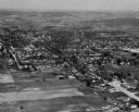
| Date: | 1957 |
|---|---|
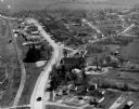
| Description: | Aerial view of various buildings and roads. |

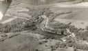
| Date: | 1955 |
|---|---|
| Description: | An aerial view of Middleton. In the foreground is a baseball field, and beyond are houses, woods, fields, and Lake Mendota. |

| Date: | |
|---|---|
| Description: | An aerial view of Governor's Island. A cutout of an arrow has been added. |

| Date: | 1956 |
|---|---|
| Description: | Aerial view of residential homes, farmland and streets. |

| Date: | 1955 |
|---|---|
| Description: | Aerial view, looking west from over Hoyt Park toward Midvale Boulevard. |
| Date: | 09 1946 |
|---|---|
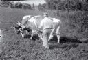
| Description: | Two oxen hitched to a yoke grazing as a farmer, Oscar Sayles, stands beside the team. The animals are named Tom and Jerry. |

| Date: | 05 1947 |
|---|---|
| Description: | Five men are driving tractors along a field. Caption reads: "Ft Atkinson Wis 1947-9 Weckler farm Neighbors help Weckler when daughter was kidnapped". |

| Date: | 1954 |
|---|---|
| Description: | Aerial view of the construction of Herbert Schenk Elementary School, as well as the surrounding neighborhood. |
If you didn't find the material you searched for, our Library Reference Staff can help.
Call our reference desk at 608-264-6535 or email us at: