Filter: Categories of Wisconsin Historical Images
Filter: Creator Name of Newhouse, John
Filter: Subject of aerial photographs
Filter: Categories of Wisconsin Historical Images
Filter: Creator Name of Newhouse, John
Filter: Subject of aerial photographs

| Date: | 1956 |
|---|---|
| Description: | Aerial view, looking eastward from a point several miles outside the southwestern limits of Madison in the direction of Verona. Crossing the image diagonal... |

| Date: | 1956 |
|---|---|
| Description: | Aerial view looking east along Madison's Lake Mendota shoreline. The large building under construction at center is Carroll Hall, a University of Wisconsin... |

| Date: | 1956 |
|---|---|
| Description: | Aerial view over the eastern end of Lake Mendota, looking northeast. Maple Bluff is in the foreground and Truax Field is in the background. |

| Date: | 1956 |
|---|---|
| Description: | Aerial view looking south from a point over the Maple Bluff country club golf course (foreground). A new housing development in the mid-ground and Maple Bl... |

| Date: | 1955 |
|---|---|
| Description: | Aerial view of Atwood Avenue, looking west towards Winnebago Street and "Schenk's Corners." |

| Date: | 1953 |
|---|---|
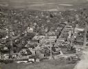
| Description: | Aerial view looking southeast over Madison's near east side. The Eagles Club at 1236 Jenifer Street / 1221 Williamson Street is under construction in the ... |

| Date: | 1955 |
|---|---|
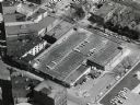
| Description: | Aerial view of the central traffic loop and Johnson Street expressway. |

| Date: | 1955 |
|---|---|
| Description: | Aerial view of the Illinois central route. The UW Fieldhouse is visible in the lower right of the image. |

| Date: | 1957 |
|---|---|
| Description: | Aerial view of Yellowstone Lake and surrounding countryside. |

| Date: | 1957 |
|---|---|
| Description: | An aerial view of Edgewood College and Schools. |

| Date: | 1953 |
|---|---|
| Description: | Aerial view of Wonewoc with hills or bluffs in the foreground on the right. |

| Date: | 1957 |
|---|---|
| Description: | An aerial view of Edgewood College and Schools. |

| Date: | 1953 |
|---|---|
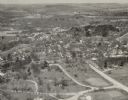
| Description: | An aerial view of Wonewoc showing central businesses and a railroad. |

| Date: | 1955 |
|---|---|
| Description: | Aerial view of river and town from a military airplane. |
| Date: | 1957 |
|---|---|
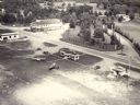
| Description: | Aerial view of the Baraboo Wisconsin Dells airport. |

| Date: | |
|---|---|
| Description: | Aerial view of the southeast, with West Broadway and the South Beltline running through the image. Also shows Nob Hill restaurant, the Toki family farm and... |
If you didn't find the material you searched for, our Library Reference Staff can help.
Call our reference desk at 608-264-6535 or email us at: