 Filter: Categories of Wisconsin Historical Images
Filter: Creator Name of Lipman, Louis, Milwaukee, Wisconsin
Filter: Type of Map or Atlas
Filter: Categories of Wisconsin Historical Images
Filter: Creator Name of Lipman, Louis, Milwaukee, Wisconsin
Filter: Type of Map or Atlas
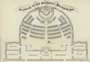
| Date: | 1862 |
|---|---|
| Description: | Diagram and seating chart for the Wisconsin State Assembly. |

| Date: | 1858 |
|---|---|
| Description: | An ink on paper map of Milwaukee County and the eastern portion of Waukesha County that shows the townships of Oak Creek, Franklin, Greenfield, Wauwatosa, ... |

| Date: | 1869 |
|---|---|
| Description: | This map was engraved from original drawings and surveys taken by Louis Lipman. Includes Milwaukee street directory on the left hand side. Bottom right cor... |
If you didn't find the material you searched for, our Library Reference Staff can help.
Call our reference desk at 608-264-6535 or email us at: