 Filter: Categories of Wisconsin Historical Images
Filter: Creator Name of Brown, Charles E.
Filter: Subject of cities and towns
Filter: Categories of Wisconsin Historical Images
Filter: Creator Name of Brown, Charles E.
Filter: Subject of cities and towns
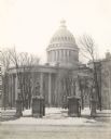
| Date: | 1899 |
|---|---|
| Description: | View from street through gates towards the Third Wisconsin State Capitol, the second in Madison, as seen from East Washington Avenue. The iron fence and st... |

| Date: | 1898 |
|---|---|
| Description: | University Heights from the Chemistry Building on University Avenue. View includes the University of Wisconsin-Madison football field, on the former site o... |
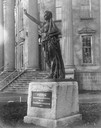
| Date: | 1893 |
|---|---|
| Description: | "Forward", the statue created by Jean Pond Miner of Wisconsin for the Wisconsin Women's Memorial at the Columbian Exposition in 1893. The statue is seen on... |
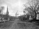
| Date: | 1898 |
|---|---|
| Description: | The third Wisconsin State Capitol as seen from unpaved West Washington Avenue, with the West Wing to the left and the South Wing to the right. The church s... |

| Date: | 1910 |
|---|---|
| Description: | Sawmill on a Menominee Indian reservation, with logs floating in the water in the foreground. Caption reads: "Menominee Indian Mills." |
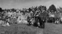
| Date: | 07 09 1919 |
|---|---|
| Description: | Governor Phillip outdoors at a victory celebration. |
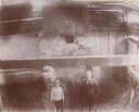
| Date: | 1885 |
|---|---|
| Description: | Elevated view of two men in the DuCharme house, later known as the Grignon house. |

| Date: | |
|---|---|
| Description: | An unusual burial mound in the Willow Drive mound group on the University of Wisconsin-Madison campus, prior to its excavation by Charles E. Brown. |

| Date: | 1915 |
|---|---|
| Description: | A row of conical burial mounds adjoins the Park and Pleasure Drive on the north shore of Lake Wingra (now Edgewood Drive, at the south edge of Edgewood Col... |

| Date: | 1910 |
|---|---|
| Description: | Exterior view of St. Andrews Episcopal Church. |
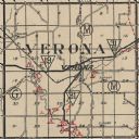
| Date: | 1924 |
|---|---|
| Description: | Map of Verona in Dane County from the Charles Brown Atlas. |

| Date: | 04 12 1912 |
|---|---|
| Description: | Diagram of a bird effigy mound found in Frost's Woods, Blooming Grove Township. |

| Date: | 1930 |
|---|---|
| Description: | This map shows Indian trails through Wisconsin counties. The trail are in red ink. Lake Michigan, Green Bay, Lake Superior, and the Wisconsin River are lab... |

| Date: | 1924 |
|---|---|
| Description: | This map of the Four Lakes region shows points of interest around the lakes, state trunk highways and other roads, railroads, and lakes and streams. Manusc... |

| Date: | 1913 |
|---|---|
| Description: | Ink and watercolor on tracing cloth. Shows parts of Green Lake, Princeton, and Brooklyn townships, Indian mound groups, Green Lake, and other significant b... |

| Date: | 1940 |
|---|---|
| Description: | This map of Aztalan is pencil and ink on paper. The map shows streets, local businesses, churches, houses, and the Crawfish River. The map reads: "Informat... |

| Date: | 1944 |
|---|---|
| Description: | Portage County Map. Includes the towns of Eau Plaine, Dewey, Sharon, Alban, Carson, Hull, New Hope, Linwood, Stockton, Amherst, Plover, Grant, Buena Vista,... |

| Date: | 1924 |
|---|---|
| Description: | A map of the Madison Township, T7N R9E including Lake Mendota showing the location of Ho Chunk encampments and effigy mounds. |
If you didn't find the material you searched for, our Library Reference Staff can help.
Call our reference desk at 608-264-6535 or email us at: