 Filter: Categories of Wisconsin Historical Images
Filter: COLLECTION_NAME of Rare Books
Filter: Subject of ocean
Filter: Categories of Wisconsin Historical Images
Filter: COLLECTION_NAME of Rare Books
Filter: Subject of ocean

| Date: | 1655 |
|---|---|
| Description: | Christopher Columbus begins his first expedition, 1492. |

| Date: | 1655 |
|---|---|
| Description: | Encounter with Indians during Christopher Columbus' first expedition in 1492. |

| Date: | 1655 |
|---|---|
| Description: | Map from Drake Expedition, ca. 1585. |

| Date: | 1784 |
|---|---|
| Description: | Plate 57. Scene from Cook's Third Expedition, 1776-1779, while in Alaska. |
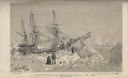
| Date: | 1838 |
|---|---|
| Description: | Position of H.M.S. Terror on the 22nd of February, 1837. The sailing ship was immobilized in the sea ice near Southampton Island, at the entrance to... |

| Date: | 02 01 1793 |
|---|---|
| Description: | Text in the upper right corner reads, "A Map of The Western Part of the Territories belonging to the United States of America. Drawn from the best authorit... |

| Date: | 1871 |
|---|---|
| Description: | A map of California showing railroad lines and reservations. |

| Date: | 1867 |
|---|---|
| Description: | A map and profile map of the railroad line from Omaha to San Francisco. |
If you didn't find the material you searched for, our Library Reference Staff can help.
Call our reference desk at 608-264-6535 or email us at: