| Date: | 1833 |
|---|---|
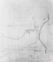
| Description: | Published in James Smith Buck's, "Pioneer History of Milwaukee". Lake Michigan is on the right, with three rivers that combine at different points and reac... |

| Date: | 1833 |
|---|---|
| Description: | Drawing on a faint grid with Lake Michigan on the right, and the rivers on the left. Labeled is an Indian Village, J. Veiu, S. Juneau, and P. Juneau. Alo... |

| Date: | 1886 |
|---|---|
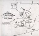
| Description: | Detail of map including plans of the National Soldiers' home. |

| Date: | 1876 |
|---|---|
| Description: | Map of home and land, with the roads, lakes, railroad, and buildings. |

| Date: | |
|---|---|
| Description: | Wisconsin Memorial Hospital with a key to buildings in the upper left. Indian mounds are marked on the site. Arthur Peabody was the state architect for th... |

| Date: | 1959 |
|---|---|
| Description: | University of Wisconsin-Madison campus. Numbers in circles identify buildings across campus with the building index. Black arrows point out important infor... |
If you didn't find the material you searched for, our Library Reference Staff can help.
Call our reference desk at 608-264-6535 or email us at: