Filter: Categories of Wisconsin Historical Images
Filter: COLLECTION_NAME of Place File****
Filter: Type of Map or Atlas
Filter: Subject of rivers
Filter: Categories of Wisconsin Historical Images
Filter: COLLECTION_NAME of Place File****
Filter: Type of Map or Atlas
Filter: Subject of rivers

| Date: | 1950 |
|---|---|
| Description: | Map showing buildings formerly used as Ringling Brothers Circus winter quarters, along with adjoining buildings. |

| Date: | 1867 |
|---|---|
| Description: | Drawn map showing planned development of Cornell, including a couple of schools, Oakwood cemetery, the public square, and several bridges and dams. |

| Date: | 1836 |
|---|---|
| Description: | The map of Wisconsin City on the Wisconsin River. |

| Date: | 1859 |
|---|---|
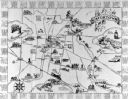
| Description: | Map featuring various views of buildings and scenes from Sauk County. |

| Date: | 1833 |
|---|---|
| Description: | Published in James Smith Buck's, "Pioneer History of Milwaukee". Lake Michigan is on the right, with three rivers that combine at different points and reac... |

| Date: | 1833 |
|---|---|
| Description: | Drawing on a faint grid with Lake Michigan on the right, and the rivers on the left. Labeled is an Indian Village, J. Veiu, S. Juneau, and P. Juneau. Alo... |
If you didn't find the material you searched for, our Library Reference Staff can help.
Call our reference desk at 608-264-6535 or email us at: